Quantcast
Channel: Arctic Northwest Passage
Viewing all 1556 articles
Browse latest View live

Battery Meltdown Averted - the devil is in the details - keep a close eye on the battery terminals and the battery cases

$
0
0
New bank of marine batteries?  Terrific!

I recommend taking detailed photos before installation so you can reference back to them over the lifetime of the batteries... be sure to mark reference numbers at each battery and terminal - else all pictures, batteries, cases and terminals will look alike a year from now...


Note The Melting of The Battery Case

The connections to your batteries matter. How you make them, how you torque them and how clean they are all matter. It can make a difference in your personal safety.

While doing a winterization, and getting ready to equalize these batteries, I noticed something strange that I could not really put my finger on, then it hit me. The battery case around the positive post was melted and un-even looking. When I grabbed the positive battery cable it was physically able to twist on the post.

Upon closer inspection - it was apparent that the battery terminal got so hot that it began melting the plastic of the battery case.

The Case & Post

The Case & Post

Here is another shot and close up of the melting of the plastic case around the positive post. This battery will now be retired because its ability to hold electrolyte may have been compromised. We have no way to see inside and inspect actual damage so as a safety precaution this battery will be recycled, even though it still tests fine. Sad really.

If you click on the photo and look closely this terminal it does not appear to have been cleaned before the terminals were re-connected in the spring. There are signs of "hot spots" in the lead and what appears to be some melting close to the stud.

This terminal was creating tremendous resistance and heat thanks to a combination of not just one, or two terminal installation errors but a third as well. The third error here is that poor cleaning and housekeeping of the terminals themselves was evident....


Another View

Another View

Here's another view of the melting of the battery case around the base of the post. it should NOT look like this. Issues like this start small but can get very problematic if left unchecked. Please keep a watchful eye when connecting and disconnecting your battery banks for anything unusual.
Reference: http://www.pbase.com/mainecruising/battery_meltdown_averted

Be safe!

Looking for more DIY boating content?

Checkout http://www.pbase.com/mainecruising/boat_projects


Medical emergency during your NW Passage - First aid or Remote or Wilderness Training?

$
0
0


Compare Remote and Wilderness Medicine

COMPARE REMOTE AND WILDERNESS TRAINING


First aid: Basic information to help you during a medical emergency. 

While better than no medical training it is only the basics - The Arctic is remote - trained medical practitioners could be hours if not days away... you would be wise to have someone as crew onboard during your expedition who is a trained medical professional else attend advanced remote or wilderness training yourself.

So what is the difference... 

THE DIFFERENCE BETWEEN REMOTE AND WILDERNESS MEDICAL TRAINING

Since 2003, Remote Medical International has been providing medical training to students with diverse backgrounds such as expeditionary guides, mountaineers, humanitarian workers, military special forces, and more. One of the most common questions we receive about our medical training courses is, “What is the difference between Remote and Wilderness medical training?” We’re here to clear up the confusion and compare the two.

WILDERNESS MEDICINE

Wilderness medicine is not just for those working outdoors or in the backcountry. It helps students prepare for the unexpected and utilise the tools they currently have available. It is utilised when ill and injured patients do not have easy access (an hour or more) or transportation to a definitive care site, such as a hospital or a clinic. The idea here is that they need to be assessed and treated immediately in the field and eventually evacuated.

REMOTE MEDICINE

Remote medical training is based on the idea of bringing as much definitive care to a remote area as possible, so that the ill or injured patient doesn’t have to be evacuated and can be treated in place and general operations can continue. This can be achieved by increasing the capability of a provider through training, having access to the right medical equipment, or using technology such as telemedicine to access appropriate medical oversight. As a result, our remote medical courses focus more on those scenarios for professionals working in remote and challenging environments and provide training on additional resources and technology such as telemedicine, how to use medical kits, and implement medical protocol under supervision.

SHOULD I LEARN WILDERNESS OR REMOTE MEDICINE, EVEN IF I’M NOT GOING INTO THE WILDERNESS OR WORKING IN A REMOTE LOCATION?

Absolutely. Even if you are in the city, things like natural disasters or even traffic accidents can make it difficult to get to a doctor or for an ambulance to arrive. Additionally, remote medical training integrates seamlessly with the ever-advancing medical capabilities of a variety of industries. Having even basic understanding allow you to better care for your family, friends, and colleagues wherever you go.

WHAT WILDERNESS MEDICINE COURSES DO YOU TEACH?

We teach a wide range of public and private medical courses with a wilderness focus. Learn more about our standard courses by clicking on the links below:

WHAT REMOTE MEDICINE COURSES DO YOU TEACH?

We teach a wide range of public and private medical courses with a remote focus. Learn more about our standard courses by clicking on the links below:
Learn With Us! 
Interested in attending one of our public training events? See partial list below. Visit our website to see the full list of public courses or to learn more about how to schedule a class privately for your group.
Work With Us! 
We're hiring! Click on the links below to see some of our highlighted jobs or visit our Online Career Portal to see all available positions. All candidates must apply via our career portal to be considered.

Climate Change Could Open Up Another Arctic Shipping Route

$
0
0

By Kate Wheeling
https://psmag.com/is-climate-change-creating-another-arctic-shipping-route-in-russia-2d726ae7e9eb

Climate Change Could Open Up Another Arctic Shipping Route

Russian researchers find that, by the end of the century, the Northern Sea Route, which hugs the Russian coast opposite the Northwest Passage, could be navigable for more than half the year.

The Ilya Muromets diesel- and electric-powered icebreaker, the newest ship for Russia’s Navy, comes off the stocks during a launching ceremony at the Admiralteyskie Verfi shipyard in Saint Petersburg on June 10th, 2016. (Photo: Olga Maltseva/AFP/Getty Images)


The Arctic is warming faster than any other region on Earth. As Arctic ice levels dwindle through hotter summers and milder winters, the region has opened up to the shipping and energy industries. A new study finds that one shipping route—the Northern Sea Route—could be navigable for more than half the year by the end of the century.

Parts of the Northern Sea Route, which runs along the Arctic coast of Russia opposite the better-known Northwest Passage, are called the Northeast Passage. The Northern Sea Route can cut the trip between Europe and Asia and North America in half, but, as Eva Hollandreported for Pacific Standard last year, Arctic trade routes were once only a pipe dream:
For European monarchs and merchants in the 16th and 17th centuries, the newly “discovered” Americas presented a problem: They were an unexpected obstacle, one whose immense size was not yet fully known, falling square between the ports of Europe and the riches of the Orient. (The construction of the Panama Canal was centuries away.) And so the era’s geographers, who traded in theories at least as often as they did in maps and surveys, posited a theoretical solution: a Northwest Passage, running over the top of North America, and its twin, a Northeast Passage atop Scandinavia and Russia.

Only in the last two decades, however, has climate change really opened up the Arctic to international shipping. In the new study, published today in Environmental Research Letters, researchers from Russia used climate models of sea-ice concentrations to predict what will happen to one optimal trade route along the Northern Sea Route in the future.

The team found that, under the climate scenario in which temperatures rise one to two degrees Celsius, the route will be navigable for a full four months out of the year. In a worst-case climate scenario, where temperatures climb by as much as four or five degrees Celsius, the route could be open for more than six months at a time. (It’s worth noting here that the latter scenario becomes far more likely should global leaders renege on their pledges under the Paris Agreement—the global climate accord that aims to limit warming to two degrees—as President Donald Trump has repeatedly threatened to do.)

But an iceless Arctic doesn’t necessarily mean smooth sailing. The authors point out that extreme winds and bigger waves will also become more likely along the Northern Sea Route. And as I wrote in October, accidents in the Arctic could amount to environmental disasters for the ecologically vulnerable region (not to mention the increased risks of sailing through a region where search-and-rescue operations are still inexperienced). Shipping along the Northwest Passage already appears to be affecting the behaviour of narwhals, as Holland reported:
“We know that in the presence of shipping, we hear a lot fewer narwhal,” [Christopher Debicki, projects director at Oceans North Canada] says, cautioning that the work so far is “preliminary presence-absence studies.” But, he emphasises, “We certainly know that, in the presence of loud anthropogenic noise, those stations are capturing a lot less narwhal sound. Which seems to suggest that they may be at least temporarily displaced by shipping.”

Of course, just because the route exists doesn’t mean that it will soon be clogged with shipping traffic—climate scientists are not in the business of predicting granular specifics about future trade routes and shipping traffic. But the opening up of the Northern Sea Route comes just as the icy relations between the United States and Russia appear to be warming up, and a new trade deal between the two nations could be in the works. Still, it’s too soon to know what such a deal might do to shipping practices along the route.

COULD THE NORTHERN SEA ROUTE (NSR) BECOME THE NEW ARCTIC YACHTING ROUTE IN THE NEAR FUTURE?


Just follow the M-O-N-E-Y to learn about abuse by so called leaders

$
0
0

Northwest Arctic Borough spends $128,000 on Seattle retreat


The Kotzebue-based Northwest Arctic Borough spent nearly $128,000 to send Assembly members to a five-day retreat in Seattle in mid-December, according to records obtained by KTUU.

http://www.ktuu.com/content/news/Northwest-Arctic-Borough-spends-128000-for-1st-Assembly-retreat-outside-Alaska-413105903.html

The trip included a special meeting, called on short notice, to vote on a controversial school construction proposal. School board members and tribal leaders in the erosion-threatened village where the school is to be built, Kivalina, said they were blindsided by the timing and location of the meeting 2,000 miles from the borough chambers.

“I just learned on the phone that this is the third meeting that the Assembly has had on this proposal,” said Stan Hawley, tribal administrator for the Native Village of Kivalina, who called in to testify by phone. “So that tells me that these meetings should be relayed to the Native village of Kivalina, likewise, way beforehand so that we can prepared and be available.”

The borough represents 11 villages near the Arctic Circle. With low oil prices choking state coffers, it has received reduced funding from the state revenue sharing program in each of the past three years.

Patrick Savok, chief of staff to Borough Mayor Clement Richards, said Richards first suggested Seattle as the venue for this winter’s retreat. (Another retreat was held in January 2016 in Anchorage. The cost of that trip was not immediately available, although a review of the mayor’s credit card receipts shows Richards charged $1,961 for a dinner gathering at a Midtown sushi restaurant. The borough finance director said she believes the dinner was attended by 15 to 20 borough officials.)

Savok said the Assembly ultimately must approve the travel and said the mayor’s team is “always cognizant” of public spending.

The meeting revealed a sharp division – at least at the time – between the mayor’s administration and the school district when Richards called for a vote on a proposal to award a construction manager project for construction of a new Kivalina school.

It was the third time in a month that the Assembly had been asked on the proposal. Previous resolutions specified Remote Solutions, a company owned by Iditarod mushers John Baker and Katherine Keith, as a recipient of the no-bid contract. An attorney for the school district wrote that the proposal might violate a state law that requires competitive bidding on such projects, while district officials argued they could perform the same work for less money.

"This decision should not be made in Seattle, Washington," school district director of property services Craig McConnell testified at the Dec. 16 meeting. "It should be made here in our region. So people can speak in person."

Savok said the location of the meeting was a matter of common-sense timing and convenience.

"I don't think there was any withholding of public involvement in any way, shape or form," he said. "The meeting just happened to coincide where all Assembly members were present."

The mayor's construction proposal failed 5-6.

"Based on the administrative actions and changes he (Mayor Richards) has made, clearly he knows that that was probably he wrong avenue to go down," Savok said.

Eugene Smith, who was chief of staff for the mayor at the time, said critics of the proposal were premature and that the plan was a good one to move forward on construction of the school in an erosion-threatened village. Savok said he was fired after the Seattle retreat as part of political blowback from the school funding dispute.

Northwest Arctic Borough spending on the Seattle trip included:
-- $49,168 for rooms, catering and other expenses at the Marriott Waterfront.
-- $34,694 for per diem for borough officials and Assembly members and meeting fees for Assembly members.
-- $32,246 in airfare.

SHAME ON YOU!!!
I HOPE YOU ARE ON THE OUTSIDE LOOKING IN NEXT ELECTION!!!
VOTE FOR CHANGE!!!

REPLAY: Cruising guru Jimmy Cornell transits the North West Passage in 2015

$
0
0

Cruising guru Jimmy Cornell transits the North West Passage in Aventura IV (finally) in 2015 (NWP #224 E6).

Yachting World
February 23, 2016

http://www.yachtingworld.com/features/jimmy-cornell-transits-the-north-west-passage-70357

ARC founder and well-known cruising author Jimmy Cornell had a boat built specially for the North West Passage, but it took two attempts and some terrifying encounters with ice to do it

The North West Passage has been described as the Everest of sailing. Since Roald Amundsen’s successful transit in 1903-1906, a total of only 94 sailing boats have been able to follow his example. For every sailor who has sailed the North West Passage, 12 climbers have scaled the highest mountain in the world.


BLOGGER COMMENT:
NW Passage transit list as of the close of 2015: http://www.americanpolar.org/wp-content/uploads/2015/10/NWP-2015.pdf

In the history of maritime exploration, no other part of the world has proved to be more difficult and has taken longer to conquer. The reason is quite simple: in spite of all the advances in boat design, technology and methods of navigation, the challenges faced by those sailing in the high Arctic have remained basically the same.

Climate change, the effects of which are more obvious in the Arctic than anywhere else in the world, has certainly played a role in making conditions for a successful transit somewhat easier but, as I found out myself on my first attempt, however well prepared you might be, Mother Nature still has the last word.
image: https://keyassets.timeincuk.net/inspirewp/live/wp-content/uploads/sites/21/2016/02/Screen-shot-2016-01-18-at-14.00.09-630x356.png

Compared with other high-latitude destinations where I have sailed in the past, the challenge posed by the North West Passage is entirely different. Whereas elsewhere the success of a voyage depends primarily on the experience of the skipper and crew, as well as the suitability of the vessel, in the North West Passage there is one major factor that is entirely out of your control: ice.

BLOGGER COMMENT:
ICE IS NOT OUT OF YOUR CONTROL WHEN YOU USE A VOYAGE ADVISER WHO CAN PROVIDE YOU WITH WEATHER, ICE MAPS AND ROUTING ADVISE. IT IS HOW YOU USE THIS INFORMATION THAT WILL GIVE YOU A STRATEGIC ADVANTAGE TURNING ICE LEMONS INTO REFRESHING LEMONADE.

Centuries of failed expeditions have resulted in a well-defined strategy for a transit, but sailors are still entirely at the mercy of ice conditions. During the short summer season, the sea ice, which has formed over the long winter, as well as the old ice left from previous winters, melts to a greater or lesser extent.

East to west passage

The ice normally retreats from west to east (Pacific to Atlantic), which means that in most years the eastern section of the North West Passage is the last to become ice-free. If planning an east to west passage, as I did in 2014, the way to deal with this is to arrive in July and wait until the ice has retreated to such an extent that a transit may be safely attempted.

image: https://keyassets.timeincuk.net/inspirewp/live/wp-content/uploads/sites/21/2016/02/Beating-out-of-Pond-Inlet-1.jpg
Beating out of Pond Inlet

In recent years, the main hurdle has been Peel Sound, the symbolic exit for boats coming from the west, and the gateway to the Passage for those from the east. This potential choke-point has been entirely blocked by ice during the last two summers, although some boats have managed to bypass it by using the shortcut of Bellot Strait.

BLOGGER COMMENT:
CHOKE-POINT ICE BLOCKAGE IS A MATTER OF POOR ROUTING AND TIMING. ARRIVING IN LANCASTER SOUND IN JULY IS NOT RECOMMENDED UNLESS YOU ARE PLANNING TO VISIT BEECHEY ISLAND AND ENJOY EXPLORING THE MANY HISTORIC SITES.

Unfortunately, in 2014 Aventura was not among them, as I decided to abandon my attempt. The lateness of the season meant that, even if we could get through, we would have to overwinter somewhere in Arctic Canada or Alaska. The prospect of ten months of virtual imprisonment was something I was not prepared to accept. (See our feature on Jimmy Cornell’s boat Aventura, designed specially for this voyage.)

BLOGGER COMMENT:
YOU MUST KNOW WHEN FREEZE-UP IS IN BOTH THE WEST AND EAST ARCTIC. IF YOU DON'T KNOW THEN YOUR VOYAGE ADVISER MUST KNOW - I.E. YACHTS WERE ABLE TO EXIT THE ARCTIC NORTHWEST PASSAGE IN OCTOBER OF 2016.

The disappointment of having failed to reach the Pacific by this historic route was more than made up for by the rich experience of the two months we spent in the high Arctic. We were fortunate to see more wildlife than we had expected, from polar bears to walrus, musk oxen to sperm whales. The weather was also generally favourable, although we did have a few exciting moments. While waiting with other boats anchored in Dundas Harbour off Lancaster Sound for the ice situation to improve, we were caught by a storm with gusts of over 60 knots.

BLOGGER COMMENT:
AVENTURA WAS BESET IN SEA ICE WHILE ATTEMPTING A CROSSING OF LANCASTER SOUND TO ARCTIC BAY IN 2014. See: http://northwestpassage2014.blogspot.com/2014/08/sv-aventura-iv-learns-firsthand-about.html

STUCK IN LANCASTER SOUND ICE.... REALIZATIONS ARE PRICELESS!!!


First attempt abandoned (2014)

The decision to turn around was painfully disappointing; we were well prepared and we’d had Aventura conceived and built for this very expedition. But what I learned from the example of Roald Amundsen and many other Arctic explorers is that challenges are there to be overcome, and that the success of any expedition depends not only on good preparation, but also on perseverance.

BLOGGER COMMENT:
AVENTURA ABANDONS 2014 NORTHWEST PASSAGE ATTEMPT SEE: http://northwestpassage2014.blogspot.com/2014/08/sv-aventura-iv-turns-back-at-beechey.html

image: https://keyassets.timeincuk.net/inspirewp/live/wp-content/uploads/sites/21/2016/02/T31A2754.jpg

So in 2015 I decided to have another try, this time from the west. Having sailed Aventura through the Panama Canal to (Costa Rica, then transported by heavy lift piggy-back ship to Vancouver) we sailed on to the North Pacific, by early July we had arrived at Dutch Harbor, a busy fishing port in the Aleutian Islands and a good place to prepare for a transit of the Passage.

BLOGGER COMMENT:
FYI Dutch Harbor is more than 200nm out of your way to the Arctic...

On a cold and misty day Aventura passed through the Bering Strait that separates America from Asia, Alaska from Siberia. That dreaded name evocative of frozen wastes and murderous labour camps flooded me with distant memories of myself as a child growing up under a Communist regime, with no prospect of escape.

Yet here I was, sailing on my own boat through what I once considered to be the very end of the world. This is, above all, what I love about sailing; the absolute freedom it gives me to go to places that I would have never dreamt of ever going.

Soon we crossed another milestone, the Arctic Circle at 66°33’27”N, regarded by some as the symbolic gateway to the North West Passage. We were now in the Chukchi Sea, which is part of the Arctic Ocean, and as the latest ice chart showed the area south of Point Barrow to be clear, we continued sailing on blissfully unaware of what lay ahead of us.

As I came on watch at midnight and started filling the log, I noticed the air temperature had suddenly plummeted to 0°C and the sea to 4°C. Ice!  (AVENTURA CREW MUST OF BEEN ONE OF THE THREE CLASSES OF PEOPLE. SEE: http://northwestpassage2014.blogspot.com/2014/08/three-classes-of-people-few-who-make.html
) I rushed into the cockpit and through the swirling mist I could make out the menacing shapes of large grey blocks of ice barely a few boat lengths away. I called the crew, we dropped the sails and started looking for a way out. We tried to steer a course towards the coast hoping that this was just an isolated patch of ice that could be easily bypassed. It was to no avail, as, on the contrary, the ice concentration was getting higher.

BLOGGER COMMENT:
USE ALL AVAILABLE MEANS... TURN ON YOUR RADAR IN RESTRICTED VISIBILITY INCLUDING THE SHORT ARCTIC NIGHT.

Trapped in ice

The situation behind us looked just as bad. Within minutes we were trapped and I estimated the concentration to be 8/10. Ice concentration is expressed in tenths: 1/10 is scattered ice, and a small boat can normally negotiate concentrations of 3/10 or even 4/10. Higher values are not easily dealt with, although a metal boat does have an advantage, as it is less at risk when having to force its way through the pack to reach an open lead. (See our feature on Cruising in Ice here.)

image: https://keyassets.timeincuk.net/inspirewp/live/wp-content/uploads/sites/21/2016/02/Alaskan-coast-at-midnight-sunset.jpg

My main concern was that the ice around us appeared to be old ice, as the floes were larger and thicker than those I had come across in the eastern Arctic. I could only presume that it had broken off the polar ice pack and had been pushed our way by the north-easterly winds. Floes of new ice are relatively thin and usually easier to push out of the way with our 4m long ice poles, but the ice surrounding us was solid, dense old ice, hard as concrete.

It soon became clear that it would only yield to a more ruthless treatment of finding a gap between two floes, and brutally ramming Aventura through. It was an adrenalin-spiked exercise that usually worked and we managed to make some modest progress, only to be caught again. On a few occasions we reached a dead-end and had to backtrack.

Turning in a tight space proved even more difficult, but with the help of the bow thruster and careful manoeuvring we got out of some really tight corners, although I shuddered to think what those repeated collisions with solid ice might be doing to our hull.

Most worrying were the underwater ledges that extended out from some of the largest floes and could not easily be seen or avoided. I knew that if one of those hit one of the rudders – or worse still, the propeller – we would be in serious trouble. As I attempted to make a hard turn in one narrow space, we hit such a submerged ledge sideways, the violent shock knocking me off my feet.

Escape from the ice

But our luck held, and although it took us over eight hours to escape that icy maze, we eventually reached open water 27 miles from the point where the pack had first taken us captive.

image: https://keyassets.timeincuk.net/inspirewp/live/wp-content/uploads/sites/21/2016/02/Searching-for-a-lead-267x400.jpg

Late that same evening we reached Point Barrow at the north-western extremity of Alaska and could finally turn east towards the North West Passage proper. At 71° 23’ N, there was nothing between us and the North Pole. Although we could see the dense ice pack close to the north of our course, there seemed to be a narrow gap along the Alaskan coast where the ice concentration was lower.

By staying in shallow water and sailing a parallel course to the coast, we could make headway at a reasonable pace, although every now and again we had to fight our way through a larger concentration of ice.

BLOGGER COMMENT:
VERY POOR DECISION TO BE SO EARLY AND PUSH THROUGH LARGE CONCENTRATIONS OF ICE... HERE IS THE RESULT OF POOR DECISIONS BY M/V ALTAN GIRL - BESET IN SEA ICE NEAR PT. BARROW. SEE: http://northwestpassage2014.blogspot.com/2014/07/sv-altan-girl-requests-help-from-uscgc.html


The drama of the previous day was soon forgotten as we motored and occasionally sailed through fields of ice, the floes reasonably spaced out to allow us to slalom between them. Being so far north we had 24 hours of daylight and we passed our time photographing the phantasmagoric shapes sculpted by sun and wind: a crowned Neptune on his throne, a pouncing crocodile, a brooding Mayan deity. It felt like walking through the gallery of a surrealist sculptor.

We continued making unexpectedly fast progress and as the ice started to thin out, we could relax and enjoy the beauty of the Arctic scenery.

As we crossed the demarcation line between the USA and Canada, Alaska and Yukon, the undulating snow-clad mountains were bathed in pastel colours by the midnight sun. It was a magic moment that lifted our spirits as we knew we had achieved the almost-impossible by having come so far long before the end of July.

Arrival in the high Arctic

We made our first Canadian landfall at Herschel Island and we could not have picked a better place of arrival in the High Arctic. Herschel Island has a rich and fascinating history and is rarely visited by boats like ours. Once a busy whaling station, the cluster of old buildings has been preserved as a capsule of times gone by and is now part of the Qikiqtaruk Territorial Park.

Just as the Arctic has been described as the canary in the mine for global weather, so Herschel is regarded as a symbol of the Arctic, as what happens in this microcosm of Arctic flora and fauna may point to the eventual consequences of climate changes in other environments.

There was a large group of scientists on Herschel Island involved in various research projects, from the depletion of the permafrost and resulting massive leaks of carbon dioxide into the atmosphere, to the greening of the Arctic and the possible effects of climate change on the endemic flora and fauna.

A German scientist, who had been monitoring conditions for several years, explained that on a much larger scale this could be the fate awaiting the vast Siberian tundra, where the accelerating instability of its permafrost would result in catastrophic consequences for the entire planet.

Migrating grizzly bear

The consequences of climate change were brought to our attention on the day of our arrival when a warden shot a large grizzly bear that had swum across from the mainland and posed a serious threat to the researchers roaming the island. He explained that grizzly bears were migrating into polar bear territory, and red foxes were displacing their Arctic cousins.

Having passed through the Western Arctic and its ice fields much earlier in the season than we had hoped, and with the ice situation still unfavourable in the east, we could slow down and turn the next stage of our voyage into a more leisurely cruise.

Our next stops were the Inuit settlements of Tuktoyaktuk and Ulukhaktok, typical of several urban centres that had been set up by the Canadian government to provide the native population with medical facilities, schools and airports.

We were warmly welcomed wherever we went as the people wanted to know what had brought us to those remote places. At Tuktoyaktuk, the mayor, Darral Nasogaluake, came to greet us. He then spoke at length about changes in their traditional way of life, now greatly influenced by the changing climate.

image: https://keyassets.timeincuk.net/inspirewp/live/wp-content/uploads/sites/21/2016/02/Tuktoyaktuk.jpg
Mooring at Tuktoyaktuk

This was obviously a matter of serious concern among the Inuit as at our next stop, in Ulukhaktok, an old man explained that the place was so quiet because many families were at summer camps, hunting and fishing for winter supplies, but nowadays had to travel much farther than ever before.

He remarked that in recent years the seasons had been visibly changing and they were seeing fish, birds and even bats they had never seen before.

He could have added Aventura to that list too as he told us that he had not seen a sailing boat like ours for more years than the fingers of his hand.

Route ahead clear

It was time to move on as the ice charts showed that the route to Cambridge Bay was no longer barred so we rushed to get there. Because of its strategic location Cambridge Bay has been described as the ‘make or break’ point for anyone attempting a transit of the North West Passage.

For those like us coming from the west and chasing the retreating ice, this is the place to pass a nailbiting time waiting and hoping that the ice will break up in the Eastern Arctic to allow us to reach our goal: the Atlantic Ocean.

The settlement of Gjoa Haven is a place no sailor will miss as it was here that Roald Amundsen spent the first two winters of his successful transit of this challenging waterway. His Gjoa was the first vessel to achieve that aim and gave her name to this Inuit settlement.

image: https://keyassets.timeincuk.net/inspirewp/live/wp-content/uploads/sites/21/2016/02/Our-welcome-committee-in-Gjoa-Haven.jpg
Our welcome committee in Gjoa Haven

However, our enjoyable stopover in Gjoa Haven had to be cut short when the latest ice charts forecast an imminent improvement in the conditions ahead of us. With more than 300 miles to go to the point that would give us access to the Atlantic, we set off immediately.

This last section of the Passage proved to be the most difficult, as we had to contend with strong contrary winds as well as our route blocked by areas of heavy ice concentration. With the prospect of achieving our aim almost within reach, we spared no effort to make good progress and pushed on towards Bellot Strait and Peel Sound, the last obstacles on the way to Greenland and the Atlantic.

image: https://keyassets.timeincuk.net/inspirewp/live/wp-content/uploads/sites/21/2016/02/Parasailor-3.jpg

We timed our arrival at Bellot Strait carefully as the 17-mile-long strait is renowned for its fierce tidal currents and can only be negotiated on a favourable tide. Halfway through the strait we passed Zenith Point, which marks the northern extremity of continental America. Having sailed my former Aventura past Cape Horn, at the continent’s southern extremity, I now had reached its northernmost.

A few days later we crossed the Arctic Circle and, in the view of those who only consider a successful transit of the North West Passage as crossing this symbolic gateway both on the way north and south, we had achieved our aim.

Since we passed the Arctic Circle on the way north 34 days earlier, we had sailed 3,728 miles and, as number 87 to have made it through, we had made one of the fastest transits recorded by a sailing vessel.

Aventura for sale

Jimmy Cornell’s Exploration 45 built by Garcia Yachting is for sale. Since her launch in April 2014, Aventura has sailed over 24,000 miles. With no plans for any future long distance voyages, Jimmy Cornell has reluctantly decided to sell this boat that has come closest to his long sought-after ideal cruising yacht. Conceived by him as a boat for all seas and all seasons the Exploration 45 is proving to be a great success with 12 similar boats already built.

Built and equipped to Jimmy’s own specifications Aventura incorporates many non-standard features and is fitted with a wide range of safety, navigation and communications equipment. Fully equipped and in perfect condition, this tried and tested boat is ready to sail to anywhere in the world. 

Aventura is offered at €599,000 (ex-VAT).

Aventura is currently docked at Cherbourg in Western France. Anyone seriously interested should send an email to info@cornellsailing.com with “Aventura Sale” as the subject.


NORTHWEST PASSAGE QUESTIONS?
I CAN HELP.
EMAIL: VOYAGEADVISER(AT)GMAIL(DOT)COM


British sailor David Cowper navigates ‘world’s most difficult sea route’ for first time since discovery in 1822

$
0
0

British sailor David Cowper navigates ‘world’s most difficult sea route’ for first time since discovery in 1822

Yachting World
October 11, 2016
http://www.yachtingworld.com/extraordinary-boats/polar-bound-extraordinary-david-cowper-purpose-built-aluminium-vessel-94424


British explorer David Cowper has become the first to transit the Hecla and Fury straits since the route was discovered in 1822. Adrian Morgan reports on one of the most respected marine explorers of all time.

image: http://keyassets.timeincuk.net/inspirewp/live/wp-content/uploads/sites/21/2016/10/Polar-Bound-1-HR.jpg


TAGS:David Cowper North West Passage Polar Bound

British sailor and explorer David Cowper has successfully transited one of the most difficult routes of the North West Passage, the Hecla and Fury Straits. On 27 August, accompanied by his son, Fred, Cowper became the first to navigate through this passage since William Parry discovered it in 1822 with the ships HMS Hecla and HMS Fury.

He departed from Maryport in Cumbria at the end of July in his strengthened and specially designed 48ft aluminium motorboat Polar Bound, navigating singlehanded to Greenland. Then, joined by his son, he continued beyond the Arctic Circle, and south of Baffin and Victoria Islands on a route considered by some to be the world’s most difficult.

Conditions were ferocious at times, with strong tidal rips, seas of 7m and more and winds gusting over 60 knots. In Hudson Strait they encountered several miles of ‘swirlers’, which he noted was ‘like being in an 18ft sea that couldn’t find its way out of a washing machine; we were trapped in the cabin being washed around with green water flying over Polar Bound.’

The boat was nearly pitchpoled and father and son were bruised from being thrown around. They lay ahull for several hours until the tide turned. David Cowper noted: ‘conditions were atrocious’.

“Nature is all powerful. Not to be held in contempt”

Polar Bound was designed by Dennis Davidson of Murray Cormack Associates and built by New Century Marine in one of the former minesweeper sheds at the old McGruers yard in Rosneath that Cowper owns. She is shaped like an egg – Cowper would rather describe her as ‘spoon-shaped’ – albeit an egg designed not to crack even under the pressure of 65 tonnes of ice.

The skin is 15mm aluminium, rising to 20mm at the shoulders and close framed, the stringers continuously welded, rather than tacked, every inch ultrasound-tested. “Nature is all powerful,” says Cowper. “Not to be held in contempt. She’s looked after me well in three circumnavigations.”


image: https://keyassets.timeincuk.net/inspirewp/live/wp-content/uploads/sites/21/2016/10/E11TY1.jpg


David Scott Cowper, the 38 year – old lone sailor from Newcastle beats Chichester’s record aboard 41ft Huisman sloop Ocean Bound. Pic: Alamy

Well known in the 1970s for his sailing exploits, Cowper undertook two circumnavigations in the Huisman-built 41ft sloop Ocean Bound. In 1979 he broke Francis Chichester’s record by a day, and two years later, sailing the ‘wrong’ way, beat Chay Blyth’s record (in the much larger British Steel) by 72 days. Before that he raced his 30ft Wanderer sloop Airedale in the 1974 Observer Round Britain and was an OSTAR entrant in 1976.

Fact: In 1982 Cowper became the fastest person to sail single-handed round the world in both directions

Cowper’s move from sail to power in 1984 was logical: whereas ice is ubiquitous in the polar regions, wind is often absent. A ‘shakedown’ cruise round the world in the 42ft cold-moulded former lifeboat Mabel E Holland made Cowper the first person to circumnavigate solo via the Panama Canal in a motor boat.

In July 1986 he left for the Arctic at the start of a solo voyage that was to last four years: via the North West Passage, during which Mabel E Holland survived a sinking while overwintering at Fort Ross, thence round the world for a second time to arrive back in Newcastle in September 1990.

Does he intend to go back to sail one day? “I might take up golf when I’m 90,” he says. “But my passion is still sailing boats. When I’m in port I go round looking at details. It intrigues me. One day I would like to design a perfect sailing boat. The ideal size would be 46ft. Most boats these days are far too sophisticated. I threw out the hot water system and desalinator. It all goes wrong.”

image: https://keyassets.timeincuk.net/inspirewp/live/wp-content/uploads/sites/21/2016/10/Polar-Bound-2-HR.jpg


Meticulous planning

Prior to this summer’s Hecla and Fury voyage, Polar Bound underwent a two-year refit, having successfully returned from the Arctic after Cowper’s fifth – and most audacious – transit of the North West Passage, via the McClure Strait, the most northerly of the seven routes, one of a number of ‘firsts’ achieved by this most modest of seafarers.

Yachting World report from 2012: David Cowper through McClure Strait

Polar Bound’s refit has been forensic. Cowper leads me down the double-dogged forehatch in the forepeak, where shelves of plastic boxes contain everything he will need on a voyage he says will last one, maybe two – who knows – three years? A vicious-looking old wooden-handled RNLI boathook rests against the hull, a relic from the Watson, used for cutting weed off clogged propellers.

Watertight bulkheads separate this from the engine room and bow compartment. The space is immensely strong. This is the second line of defence, the first being a stem, already super-strong, further protected by a sharp, hefty strip of aluminium.

Every seacock and valve is accessible; every one has been dismantled and greased. Cowper has a tool for everything. A Dickinson Bering stove in the saloon, insulated with one tonne of rock wool, has been nickel-plated. “I hate rust,” he says with a passion you might express about mice in the rafters.

image: https://keyassets.timeincuk.net/inspirewp/live/wp-content/uploads/sites/21/2016/10/Cowper-614-HR.jpg


Cowper was the first person to transit the McClure Strait, the most northerly navigable route of the Canadian North West Passage.

Meticulous planning underpins everything he does. The 18mm toughened glass wheelhouse windows, as fitted to RNLI lifeboats, and 10mm polycarbonate side windows – Polar Bound is self-righting – have been removed and rebedded; the wipers – “very poor, all mixtures of metals” – dismantled and rebuilt.

Meticulous, but frugal. The man himself is spare. The shower looks unused. “Clean people don’t need a shower,” he says, apparently quite seriously, although I can’t be sure.

Yet expense is not spared on the essentials. The air-damped wheelhouse seat was bought cheaply off a police boat. Polar Bound carries £20,000 worth of diesel, much of which he intends to buy in Greenland “where it’s subsidised”.

At the heart of every Polar Bound voyage is a piece of reciprocating machinery that must match its owner in strength, resilience and reliability: the Gardner eight-cylinder LXB 150hp diesel engine that for thousands of sea miles in polar, Pacific, Atlantic, Indian Ocean and Antarctic waters has turned a four-bladed 3ft bronze propeller (one of two; he carries a spare). At a steady 900 revolutions per minute, hour after hour, day after day, it is akin to a human heart, and just as vital.

image: https://keyassets.timeincuk.net/inspirewp/live/wp-content/uploads/sites/21/2016/10/Cowper-1927-HR.jpg


Perfectionist tendencies

A fellow of the Royal Institution of Chartered Surveyors, with a business to run back in Newcastle, Cowper is still at work, as frequent calls to his mobile attest. In 1986, returning from the Arctic, where Mabel E Holland had been left after failing to force the Bellot Strait, he worked his passage home on the Esso Imperial “peeling potatoes”.

His first yacht, the 30ft Laurent Giles Wanderer Airedale, he bought as a student for £5,000. “All my money at the time,” he recalls.

“I’ve been fortunate, always having had new yachts,” Cowper says, a luxury that does not come cheap given he has eschewed, or rather failed to attract, significant sponsorship over the years. “I gave up trying to be a global superstar years ago.”

Besides, sponsorship would bring with it obligations: to talk, interview, lecture, endorse, meet people. Not that he shows the slightest unease or reticence, let alone irritation, at answering questions and is comfortable in front of a camera. You get the impression that he would relish a little more recognition, but the relative lack of it does not bother him unduly. Named Yachtsman of the Year in 1990, he has a devoted following among those who matter, which is all that matters to him.

Those records cannot lie: his Ocean Bound feats aside, he will always be first to circumnavigate the world non-stop in a motor boat and to transit the North West Passage alone, and more besides. Between 2009 and 2011 he completed the voyage westward through the passage, down the coast of South America to the Antarctic, South Georgia – “My favourite place; special, unmolested wildlife” – via Cape Town to Australia, Fiji, Hawaii and doubling back again east, via the Passage. It was his sixth solo circumnavigation, and another first.

image: https://keyassets.timeincuk.net/inspirewp/live/wp-content/uploads/sites/21/2016/10/Engine-HR.jpg


Jane Maufe – his somewhat younger, able crew and companion – who was aboard for his 2012 transit via the McClure Strait, describes him as “a perfectionist” and “old school, in the nicest possible way”.

“He has strong opinions about lots of things,” she says. “He’s also very knowledgeable.” Of the exploitation of the Arctic by charter boats and cruise ships he is scathing: “People want instant satisfaction. Accidents waiting to happen. It’s not a place to fool around in or take for granted. It may be a little easier than 20 years ago, with global warming, but conditions change in one season. There’ll be Beneteaus cracking like matchsticks.”

Of keels falling off or foiling yachts doing 30 knots with one person aboard, glued to tablets: “Highly dangerous.” His chart table is full Admiralty-sized and watched over by two St Christopher medallions. Is he superstitious? “Well, I would not want to sail on Friday 13th.”

image: https://keyassets.timeincuk.net/inspirewp/live/wp-content/uploads/sites/21/2016/10/Cowper-and-Jane-2-HR.jpg


David Cowper with his companion and co-adventurer Jane Maufe

So why is he not better known? It could be down to his age, lack of vanity, or quite simply the fact that most people see the world as a Mercator projection. It is only when you look at a globe that you can grasp what the “circumnavigation via the poles” – something Cowper has achieved twice, both east to west and vice versa – means.

It means hundreds of hours alone at the wheel, plugging on; of stifling fogs and brutal gales, and a vista of endless ice. Of bergs and bergy bits, and searching for elusive leads; of backtracking and frustration, danger. And always ice, the lure of which has drawn explorers north and south for centuries.

To Cowper the Arctic means “going into an antiques shop; back into history” where the shades and in some cases the bones of famous explorers still reside. Of McClure, Parry, McClintock, Franklin, Bellot and Ross, whose names are forever associated with straits, sounds and passages. There is now a Mabel E Holland Point at Fort Ross, near where she sank over the winter and Cowper raised her.

At his early Victorian house in Newcastle – formerly owned by the Barbour family – he stores a vast amount of gear, equipment and charts, as well as a collection of first editions of great explorers. Either he has a keen eye for their future value or, more likely, feels he is sailing in their wake.

“You can’t compare today’s voyagers with the old ones,” he says. “We are a relatively soft nation. They were pioneers – they didn’t know the answers. Scott was much maligned. Cook was a fantastic sailor. Should have been made a lord.”

A ghosted account of his Mabel E Holland adventures sold 10,000 copies, but he says that, although well written, he “didn’t really recognise himself in it”. Probing as to why he does it only elicits enigmatic or evasive answers. Finally he says: “Oh, it’s to get away from people”, with a smile that betrays the truth; for he clearly enjoys company, albeit of the right kind. “I don’t like people screaming at you,” he says. “Better to be on my own.”

image: https://keyassets.timeincuk.net/inspirewp/live/wp-content/uploads/sites/21/2016/10/Frozen-Frontier-HR.jpg


Competent crew

There are clear exceptions: his son Freddie who accompanied him for several legs of previous voyages to Norway, the Azores and Iceland, and Jane Maufe, who shares his unflappable enthusiasm.

Maufe, fourth great niece of Rear Admiral Sir John Franklin, is retired from a Norfolk antiques business. “He told me I had ‘no annoying habits’,” she says. A “first class cook in all conditions,” adds Cowper. “We never missed a meal in all the time we were at sea. We eat exceedingly well.”

A highly competent crew, companion in adversity, diplomat, negotiator and fellow adventurer, she recalls being handed a Browning rifle at Fort Ross: “David wanders away completely unarmed with the bullets in his pocket and tells me that if I meet a bear I should click two stones together, then it buggers off.” It was a threat not to be taken lightly as a polar bear once “bounced up and down” on the Tinker Traveller that Polar Bound carries under a derrick on the aft deck.

Read more at http://www.yachtingworld.com/extraordinary-boats/polar-bound-extraordinary-david-cowper-purpose-built-aluminium-vessel-94424

Planning your Northwest Passage for 2017?

Questions?

I can help!

Email: voyageadviser(AT)gmail(DOT)com


Bogoslof (Alaska) volcano's continuing eruptions, island has tripled in size - Remember to download the most current updated marine navigation charts

$
0
0
https://www.adn.com/alaska-news/2017/02/18/with-bogoslof-volcanos-continuing-eruptions-island-has-tripled-in-size/

With Bogoslof volcano's continuing eruptions, island has tripled in size


Bogoslof volcano erupted once again early Saturday morning as a series of rumblings continue that have so far tripled the island's size.
Around 4:30 a.m. Saturday, an eruption lasting a few minutes shot an ash cloud at least 25,000 feet into the sky, the Alaska Volcano Observatory wrote in an activity notice.
Bogoslof volcano rises from the sea about 60 miles west of Dutch Harbor, in Alaska's Aleutian Islands.
"We're basically just seeing the tiptop of the volcano itself," Jeff Freymueller, coordinating scientist for the Alaska Volcano Observatory at University of Alaska Fairbanks' Geophysical Institute, said of the island.
Bogoslof isn't considered an especially active volcano. Scientists have recorded eight eruptive events since 1796. The last one was in 1992, for about three weeks in July, Freymueller said.
Since eruptions began on Dec. 12, rock fragments and ash — called tephra — have been erupting from Bogoslof, Freymueller said. The result is a landscape that has shifted and grown dramatically in the past few months.


Bogoslof eruptions began Dec. 12, 2016, and by Jan. 31, 2017, had roughly tripled the size of the island. (Chris Waythomas, Alaska Volcano Observatory / U.S. Geological Survey)
As of Jan. 31, the island was just over .38 square miles (1 square kilometer), about three times its size before the series of eruptions started in December. This new land, created from tephra, will be highly susceptible to wave erosion, and the island's shoreline will likely continue to change, Freymueller said.
Sometimes those changes are quick. A composite image shows how much the island morphed just between Jan. 16 and Jan. 18.


Bogoslof’s shifting shoreline. The base image is from Jan. 11. The green line is the shoreline on Jan. 16, and the orange dotted line shows the shoreline on Jan. 18. (Kim Angeli, Alaska Volcano Observatory / U.S. Geological Survey)
There's no telling how long this series of eruptions will last, Freymueller said. Eruptions in the early 20th century lasted more than a year, he said, but the 1992 eruption was brief.

USA free marine navigation chart downloads are at:

NOAA RNCs are geo-referenced digital images of the charts in BSB format.
NOAA ENCs are vector files of chart features and available in S-57 format.

NOAA RNCs & ENC's are updated weekly with Notice to Mariner corrections.

NOAA PDFs are full-size, high-resolution printable images of the charts.

Chart Locator:
The chart locator displays the outlines of the RNCs, PDFs,
ENCs and Coast Pilot regions. These products can be selected and
downloaded from this interface. Google Maps is used as the
background display and search options. To the right of the
map display is an area that shows status and product information.


Questions?

I can help!

Email: voyageadviser(AT)gmail(DOT)com


What if, the Arctic 2017 minimum sea ice season started a month early? Would it extend later than last year?

$
0
0

Unprecedented Arctic Weather Has Scientists on Edge. As station chief at NOAA's Point Barrow, Alaska, observatory, Bryan Thomas works close to the edge of the Arctic Ocean. What he saw from his office in early February, looking north toward the horizon, was troubling. "I could see what's known as water-sky - the reflection of dark water on clouds on the horizon," Thomas said. "From land, you can maybe see 10 miles, and the clouds were telling us that somewhere in that distance there was open water." National Oceanic and Atmospheric Administration


More of the story: http://www.noaa.gov/media-release/unprecedented-arctic-warmth-in-2016-triggers-massive-decline-in-sea-ice-snow


Arctic temperatures will be dropping in 2020

$
0
0

AARI scientists: Arctic temperatures will drop starting in 2020

Russian scientists predict that Arctic temperatures will start dropping in the early 2020s. In the past decade, average Arctic temperatures have increased by three degrees, Valery Karklin, a research associate with the Arctic and Antarctic Research Institute, told the TASS news agency. In the future, he predicts a drop in temperatures in the region.


"Our forecast shows that Arctic temperatures will begin to drop in the early 2020s, and this trend will continue until the 2030s and 2040s. Therefore ice formations will expand in Arctic seas, and the frequency of difficult ice conditions will increase. Due to continued warming over the past ten years, positive average annual temperature aberrations in the Arctic zone (north of the 70th parallel, northern latitude), fluctuated between 1.7-4 degrees Celsius, averaging three degrees. In other words, the Arctic zone has warmed by three degrees," Karklin said.


The AARI research supports the theory that global warming is the result of cyclical climate fluctuations with a period of about 60 years, TASS reports. Global warming is caused by natural factors and is not linked with human activity, the scientists say. "It should be noted that, according to various sources, ambient air temperatures in the northern hemisphere have stabilized since 1998 and have started gradually dropping. This process has not yet begun in the Arctic," Karklin explained.

Bylot Island Circumnavigation - "North to the Night by Alvah Simon (Tay Bay on Bylot Island)

$
0
0


Bylot Island Circumnavigation
Tue., Feb 21, 2017 |
By John C.
Thr Bear Witness Arctic Expedition, with which St. Michael Catholic School in Fitzroy Harbour is involved, will see a four-member international team of explorers led by David Reid to circumnavigate Bylot Island in Nunavut on skis.

Bylot Island is located off the northern tip of Baffin Island in the Canadian high Arctic.


The expedition, which will take a month to complete, is being done not only to celebrate Canada’s 150th anniversary year of 2017 but also to create awareness of the climate and other challenges being faced in the Arctic.


Bylot Island itself is situated more than 700 kilometres above the Arctic Circle. It will be the largest island in the world ever to be circumnavigated on skis thanks to this Bear Witness Arctic Expedition.


It is the 17th largest island in Canada, measuring 180 kilometres from east to west and 110 kilometres from north to south. It is one of the largest uninhabited islands in the world. While there are no permanent settlements on Bylot Island, Inuit from Pond Inlet on Baffin Island regularly travel to the island.

Angilaaq Mountain (the highest point on the island at just over 6,400 feet), Malik Mountain, Mount St. Hans, and Mount Thule are the most prominent mountains on Bylot Island. Tay Bay (made famous by Alvah Simon's book North To The Night) is located on the northwest coast. Just south of Tay Bay is Canada Point. It was here in 1906 that Captain Joseph-Elzéar Bernier claimed the island for Canada). The most famous visitor to Bylot was the renowned Inuit leader Qitdlarssuaq who, in 1850, spent time on the island during his epic polar migration. The journey started in the Cumberland Sound area of Baffin Island and ended in the Thule area of northwest Greenland.


Almost all of Bylot island is contained within Sirmilik National Park. "Sirmilik" is an Inuktituk word meaning "Place of Glaciers." The island's north shore faces Lancaster Sound, across to Devon Island and the eastern entrance to the famous Northwest Passage. The north coast of Bylot Island is rarely visited by anyone and only a relatively few photographs and videos exist to show both its topography and character.


The north coast is also known as a major polar bear denning area. Narwhal, beluga, bowhead whale, harp, ringed and bearded seal frequent the area during the spring and summer. On the north west coast can be found Cape Hay, one of the most important breeding and nesting areas for a variety of birds including thick billed Murres and black-legged Kittiwakes.


The island was given its name after the Arctic explorer Robert Bylot, the first European to sight it in 1616.


The entire Bear Witness Arctic Expedition will take place within the boundaries of the proposed Lancaster Sound National Marine Conservation Area. Lancaster Sound is a rich Arctic ecosystem which features polar bears, narwhals, bowheads, belugas, several species of seals, walrus and thousands of sea birds. Being a National Marine Conservation Area would protect this wildlife.


Members of the expedition team include David Reid, a veteran and experienced Arctic explorer and guide; Eric Brossier who studies biodiversity and climate change in the Arctic; Ingrid Ortlieb, an adventurer who has participated in many expeditions in many parts of the world including a trip through the Northwest Passage; and Martin Garcia, another lifelong adventurer.


U.S. Coast Guard Awards Heavy Polar Icebreaker Contracts

$
0
0

U.S. Coast Guard Awards Heavy Polar Icebreaker Contracts


The Coast Guard Cutter Polar Star, with 75,000 horsepower and its 13,500-ton weight, is guided by its crew to break through Antarctic ice en route to the National Science Foundation's McMurdo Station, Jan. 15, 2017. The ship, which was designed more than 40 years ago, remains the world's most powerful non-nuclear icebreaker. (U.S. Coast Guard photo by Chief Petty Officer David Mosley)
The USCGC Polar Star, the United States’ only operational heavy icebreaker, is guided through Antarctic ice en route to the National Science Foundation’s McMurdo Station, Jan. 15, 2017. The icebreaker is now over 40 years old. U.S. Coast Guard Photo

The U.S. Coast Guard on Wednesday awarded five firm fixed-price contracts for heavy polar icebreaker design studies and analysis.
The contracts were awarded to the following recipients: Bollinger Shipyards, LLC, Lockport, Louisiana; Fincantieri Marine Group, LLC, Washington, District of Columbia; General Dynamics/National Steel and Shipbuilding Company, San Diego, California; Huntington Ingalls, Inc., Pascagoula, Mississippi; and VT Halter Marine, Inc., Pascagoula, Mississippi.
The combined total value of the awards is approximately $20 million.
The objective of the studies are to identify design and systems approaches to reduce acquisition cost and production timelines. In addition to a requirement to develop heavy polar icebreaker designs with expected cost and schedule figures, the contracts require: the awardees to examine major design cost drivers; approaches to address potential acquisition, technology, and production risks; and benefits associated with different types of production contract types.
The heavy polar icebreaker integrated program office, staffed by Coast Guard and U.S. Navy personnel, will use the results of the studies to refine and validate the draft heavy polar icebreaker system specifications. The use of design studies is an acquisition best practice influenced by the Navy’s acquisition experience with the Landing Craft, Utility (LCU) amphibious transport ship and T-AO(X) fleet oiler, which are being acquired under accelerated acquisition schedules.
“These contracts will provide invaluable data and insight as we seek to meet schedule and affordability objectives,” said Rear Adm. Michael Haycock, the Coast Guard’s Director of Acquisition Programs and Program Executive Officer. “Our nation has an urgent need for heavy polar icebreaking capability. We formed an integrated program office with the Navy to take advantage of their shipbuilding experience. This puts us in the best possible position to succeed in this important endeavor,” said Haycock.
“The Navy is committed to the success of the heavy icebreaker program and is working collaboratively with our Coast Guard counterparts to develop a robust acquisition strategy that drives affordability and competition, while strengthening the industrial base,” said Jay Stefany, Executive Director, Amphibious, Auxiliary and Sealift Office, Program Executive Office, Ships. “Our ability to engage early with our industry partners will be critical to delivering this capability to our nation,” said Stefany.
The studies are expected to take 12 months to complete, with study results provided incrementally during that time. The Coast Guard plans to release a draft request for proposals (RFP) for detail design and construction by the end of fiscal year 2017, followed by release of the final RFP in fiscal year 2018. The Integrated Program Office plans to award a single contract for design and construction of the lead heavy polar icebreaker in fiscal year 2019, subject to appropriations

Global warming by man or planet earth solar radiation cycles? You decide...

$
0
0


Watts Up With That?
The world's most viewed site on global warming and climate change.

Claim: Air pollution may have masked mid-20th Century sea ice loss


From the American Geophysical Union:
Melt pools on melting sea-ice. New research shows humans may have been altering Arctic sea ice longer than previously thought. Credit: NASA.
WASHINGTON, DC — Humans may have been altering Arctic sea ice longer than previously thought, according to researchers studying the effects of air pollution on sea ice growth in the mid-20th Century. The new results challenge the perception that Arctic sea ice extent was unperturbed by human-caused climate change until the 1970s.
Scientists have observed Arctic sea ice loss since the mid-1970s and some climate model simulations have shown the region was losing sea ice as far back as 1950. In a new study, recently recovered Russian observations show an increase in sea ice from 1950 to 1975 as large as the subsequent decrease in sea ice observed from 1975 to 2005. The new observations of mid-century sea ice expansion led researchers behind the new study to the search for the cause.
The new study supports the idea that air pollution is to blame for the observed Arctic sea ice expansion. Particles of air pollution that come primarily from the burning of fossil fuels may have temporarily hidden the effects of global warming in the third quarter of the 20th Century in the eastern Arctic, the researchers say.
These particles, called sulfate aerosols, reflect sunlight back into space and cool the surface. This cooling effect may have disguised the influence of global warming on Arctic sea ice and may have resulted in sea ice growth recorded by Russian aerial surveys in the region from 1950 through 1975, according to the new research.
“The cooling impact from increasing aerosols more than masked the warming impact from increasing greenhouse gases,” said John Fyfe, a senior scientist at Environment and Climate Change Canada in Victoria and a co-author of the new study accepted for publication in Geophysical Research Letters, a journal of the American Geophysical Union.
To test the aerosol idea, researchers used computer modeling to simulate sulfate aerosols in the Arctic from 1950 through 1975. Concentrations of sulfate aerosols were especially high during these years before regulations like the Clean Air Act limited sulfur dioxide emissions that produce sulfate aerosols.
The study’s authors then matched the sulfate aerosol simulations to Russian observational data that suggested a substantial amount of sea ice growth during those years in the eastern Arctic. The resulting simulations show the cooling contribution of aerosols offset the ongoing warming effect of increasing greenhouse gases over the mid-twentieth century in that part of the Arctic. This would explain the expansion of the Arctic sea ice cover in those years, according to the new study.
Aerosols spend only days or weeks in the atmosphere so their effects are short-lived. The weak aerosol cooling effect diminished after 1980, following the enactment of clean air regulations. In the absence of this cooling effect, the warming effect of long-lived greenhouse gases like carbon dioxide has prevailed, leading to Arctic sea ice loss, according to the study’s authors.
The new study helps sort out the swings in Arctic sea ice cover that have been observed over the last 75 years, which is important for a better understanding of sea ice behavior and for predicting its behavior in the future, according to Fyfe.
The new study’s use of both observations and modeling is a good way to attribute the Arctic sea ice growth to sulfate aerosols, said Cecilia Bitz, a sea ice researcher at the University of Washington in Seattle who has also looked into the effects of aerosols on Arctic ice. The sea ice record prior to satellite images is “very sparse,” added Bitz, who was not involved in the new study.
Bitz also points out that some aerosols may have encouraged sea ice to retreat. Black carbon, for instance, is a pollutant from forest fires and other wood and fossil fuel burning that can darken ice and cause it to melt faster when the sun is up – the opposite effect of sulfates. Also, black carbon emissions in some parts of the Arctic are still quite common, she said.

Cruising Club makes 2016 awards - misses greatest yachtsman

$
0
0
David Scott Cowper - 2012 Blue Water Metal Award

The world's greatest yachtsman fails to be recognized by the Cruising Club of America for his 2016 achievement of being the first yachtsman ever to navigate aboard his yacht, M/V POLAR BOUND, west through Fury and Hecla Strait to complete the first Northwest Passage Route-7 West transit.

Sad to think that Club officers are so poorly informed.

http://www.cruisingworld.com/cca-selects-2016-award-winners

http://arcticnorthwestpassage.blogspot.com/2016/09/mv-polar-bound-turns-corner-in-sea-ice.html

http://arcticnorthwestpassage.blogspot.com/2016/12/northwest-passage-route-7-transits-as.html

http://arcticnorthwestpassage.blogspot.com/2016/09/mv-polar-bound-gb-completes-world.html

https://en.m.wikipedia.org/wiki/David_Scott_Cowper


Arctic 2017 greening 26 days early than 2005

$
0
0
https://mobile.nytimes.com/2017/02/27/science/arctic-plants-spring-global-warming.html

Abstract

We analysed 12 years of species-specific emergence dates of plants at a Low-Arctic site near Kangerlussuaq, Greenland to investigate associations with sea ice dynamics, a potential contributor to local temperature variation in near-coastal tundra. Species displayed highly variable rates of phenological advance, from a maximum of −2.55 ± 0.17 and −2.93 ± 0.51 d yr−1 among a graminoid and forb, respectively, to a minimum of −0.55 ± 0.19 d yr−1 or no advance at all in the two deciduous shrub species. Monthly Arctic-wide sea ice extent was a significant predictor of emergence timing in 10 of 14 species. Despite variation in rates of advance among species, these rates were generally greatest in the earliest emerging species, for which monthly sea ice extent was also the primary predictor of emergence.Variation among species in rates of phenological advance reshuffled the phenological community, with deciduous shrubs leafing out progressively later relative to forbs and graminoids. Because early species advanced more rapidly than late species, and because rates of advance were greatest in species for which emergence phenology was associated with sea ice dynamics, accelerating sea ice decline may contribute to further divergence between early- and late-emerging species in this community.


Arctic Security and Legal Issues in the 21st Century

$
0
0

http://www.maritime-executive.com/editorials/arctic-security-and-legal-issues-in-the-21st-century


Arctic Security and Legal Issues in the 21st Century

yamal
The Russian nuclear icebreaker Yamal (file image)

By CIMSEC 2017-03-01 20:11:48
[By Sally DeBoer]
The changing Arctic is a topic of increasing interest to the maritime security community. Rapidly receding sea ice and increasingly navigable waters combined with the promise of rich natural resource deposits have made investment in the Arctic – particularly military and infrastructure investment – a priority for Arctic nations and other parties that stand to benefit from the region. To discuss these issues and more, CIMSEC interviewed Commander Sean Fahey, USCG of the U.S. Naval War College Stockton Center for the Study of International Law for his expert insight on legal and security issues in the High North in the 21st Century. 
SD: Commander Fahey, thank you so much for taking the time to discuss legal and security challenges to the Arctic in the 21st Century. To begin, can you tell us a little about yourself and your background?
SF: Great to be with you; thank you for the invitation. I serve as the Associate Director for the Law of Maritime Operations at the Stockton Center for the Study of International Law, at the U.S. Naval War College. In this role, I conduct research and teach global maritime security law. In particular, I focus on the intersection of law and security in the Arctic Ocean. For example, I recently collaborated with Professor James Kraska on a position paper for the U.K. House of Commons Defence Sub-Committee, Defence in the Arctic Inquiry. I am also the Editor-in-Chief of International Law Studies, the Stockton Center’s peer-reviewed law journal, and the oldest journal of international law published in the United States.
By way of background, I am an attorney and commissioned officer in the rank of commander in the United States Coast Guard, and have advised various levels of command on the legal issues impacting maritime security operations, primarily counter-drug, fisheries enforcement, migrant interdiction and environmental law enforcement. I have also served as a Trial Attorney for the U.S. Department of Justice and as a legal advisor in the operational law division of USAFRICOM, where my focus was on maritime security operations, namely counter-piracy and maritime law enforcement support, and counter-terrorism.
SD: Can you characterize the United States’ current position in the Arctic? Is the U.S. prepared – materially and strategically – for challenges ahead in the Arctic?
SF: The United States is an Arctic nation, and the region is of significant strategic, economic and environmental importance to us. Some of the challenges we face in the region, for example, energy and mineral exploitation, are future challenges, but many, such as preserving freedom of navigation and overflight, are immediate. Climate change – whatever the cause – promises to be a major factor in how we prioritize our responses to those challenges, but it is not the only factor. Our strategy is influenced by the actions and priorities of the other Arctic nations as well, and in some areas the United States is not in the lead.
Strategically, we have comprehensive guidance on how to structure our approach to the region. American priorities are set forth in National Security Presidential Directive-66/Homeland Security Directive-25 and the “National Strategy for the Arctic Region,” and the accompanying Implementation Plan. Broadly, U.S. strategy is to advance U.S. security interests, pursue responsible Arctic stewardship, and strengthen international cooperation in the region. Each of those priorities has several detailed lines of effort. For example, the U.S. has four primary lines of effort to promote security: (1) preservation of freedom of navigation and overflight throughout the Arctic region; (2) enhancement of Arctic regional domain awareness and presence; (3) development of future U.S. energy security; and (4) evolve Arctic strategic capabilities, military force structure, and civilian infrastructure to be able to best respond to challenges unique to the region.
Many of the federal departments and agencies tasked with taking the lead on a particular line of effort within the national policy further refine the National strategy with additional guidance documents, among them the U.S. Coast Guard and Department of Defense. So, in response to the second part of your question – is the United States prepared for future challenges in the Arctic?Strategically we are. We know the priorities and we know who is responsible for advancing them. Materially, however, the United States is not in the best position it could be to advance its strategic priorities. The most pressing example of this lacuna is the requirement for icebreakers.
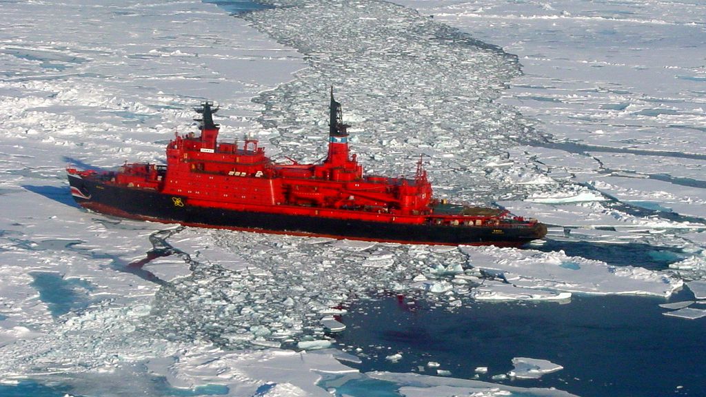
Enhanced icebreaking capabilities are vital to properly support U.S. security interests in the Arctic. You cannot be present if you cannot get there. Virtual presence is actual absence. A persistent presence in the Arctic region is a condition precedent for the effective exercise of law enforcement jurisdiction and improved domain awareness. Currently, the U.S. has two icebreakers. The Russian Federation has 37. A fleet of at least six heavy icebreakers would provide one full-time U.S. presence within the Arctic Ocean in both the east and west, while also allowing enough hulls for training, work-ups, and post-deployment maintenance. This requirement is supported by the Pentagon, and is the single most important capability for the U.S. to pursue in the Arctic. Only a robust ice-breaking capability allows the U.S. to respond to all threats and all hazards in the region.
SD: The United States is in a time of flux, politically – how do you think a U.S. position that is perhaps less invested in preventing the effects of climate change might affect the security situation in the Arctic and the role of the U.S. as an Arctic leader?
We certainly are in a time of flux, but it is too early to say how the administration will address the challenges posed by climate change. Time will tell. That said, the data on the environmental changes occurring in the Arctic are alarming. According to the National Snow and Ice Data Center, which is directly supported by NASA and NOAA, the minimum Arctic sea ice extent has reduced by 40 percent since 1978. Last year the maximum (wintertime) sea ice extent was at a record low for a second year in a row. Additionally, NASA reports that global surface temperatures – to include in the Arctic – were at record highs in 2016. In short, the data indicate that the melt will not only continue, but will likely accelerate.
SD: Can you speak to some of the impacts that climate change has had on the Arctic security situation?
SF: The changing Arctic climate has already had a recognizable impact on the regional security landscape. Less ice means greater access and more activity. Some of the impacts may be positive. For example, the Arctic has enormous importance for long-term U.S. energy security. The U.S. Geological Survey (USGS) estimates that 13 percent of the world’s undiscovered oil reserves (90 billion barrels) are in the Arctic. This estimate is in addition to more than 240 billion barrels of petroleum reserves that have already been discovered. The USGS estimates that one-third of this oil is in the circum-Arctic region of Alaska and the Alaskan Outer Continental Shelf (OCS). Responsibly and safely developing new domestic energy sources strengthens U.S. energy security by reducing U.S. reliance on imported oil, some of which, as you know, travels vast distances from extremely unstable regions before entering the national supply.
That said, competition for energy resources in disputed areas of the Arctic could destabilize the regional security balance. I am confident however, that the United States and the other Arctic nations will resolve their boundary disputes peacefully. We have seen evidence of this already with the Russian Federation and Norway resolving a long-standing maritime border dispute in the Barents Sea.
The more immediate impact of climate change on the Arctic security situation will be on freedom of navigation and overflight in the region. Broadly speaking, freedom of navigation and overflight are critical for the U.S. to be able to support peacetime and wartime contingencies across the globe. If the Arctic ice melt continues at its current pace, the Northwest Passage, the shipping route along the Canadian Arctic coastline, and the Northern Sea Route, the shipping route along the Russian Arctic coastline, will be accessible for longer periods of time, possibly year round.
Strategic mobility throughout the Arctic could become critical to support strategic sealift for U.S. contingency operations worldwide, and the Northwest Passage and Northern Sea Route could serve as waterways to support such contingency operations. Portions of both shipping routes cross areas where the respective coastal state has made, in the opinion of the U.S., an excessive maritime claim, and these claims threaten the ability of naval forces to exercise their navigational and overflight rights. Preserving these rights is a central tenet of the National Arctic strategy. The U.S. Department of State, the lead agency for this strategic priority, is actively engaged with Canada and Russia on this issue, but it may be prudent for the United States to conduct freedom of navigation operations – the peaceful exercise of international legal rights in disputed sea areas – in areas of the Arctic Ocean that are subject to unlawful maritime claims.
SD: Many of our readers may not be aware of the pivotal role the U.S. and international Coast Guards have in maritime operations, specifically on operations in the high north. What improvements could the United States make to its infrastructure to be more prepared for operations in the Arctic?
At the risk of sounding redundant, I think greater icebreaking capability, and the shore-based infrastructure required to support icebreakers, is absolutely critical for the U.S. to achieve its maritime security goals in the Arctic. In order to respond to regional threats and hazards, U.S. surface forces need to be able to safely navigate the Arctic Ocean.
In the same vein, the U.S. should also commit to constructing ice-strengthened patrol ships for its seas services, similar to the Arctic Offshore Patrol ships being commissioned by the Royal Canadian Navy. The increased security presence in the region that greater icebreaking capability and ice-strengthened patrol ships would enable will help further deter conventional and unconventional maritime security threats and also ensure that U.S. near-shore and offshore oil and gas industry infrastructure is properly safeguarded. Search and rescue (SAR) also requires both ships and aircraft that are capable of operating in extreme climate. The United States has inadequate force structure to meet SAR contingencies.
Additionally, the U.S. needs to strengthen is pollution response capabilities and infrastructure in the Arctic. Needless to say, as the energy sector expands in the Arctic, so too does the risk of pollution. Given the remoteness of the region, sufficient pollution response capabilities and infrastructure need to be in place and accessible in order to ensure a timely response.
Finally, as the region becomes more accessible to year-round commercial navigation, the U.S. needs to ensure we have the sufficient infrastructure to support safe and secure maritime commerce. This could include harbor and dock improvements, aids to navigation, management systems for high risk vessel traffic areas,  search and rescue capabilities, and effective communications networks. Some of these are in place, some just need to be enhanced, and some need to be created.
SD: As you are a legal scholar, we’d like your insight on competing maritime claims in the region. First, what legal foundation, if any, does Canada have for its claim over the Northwest Passage? We know this is a controversial topic; what does the letter of the law dictate on the matter?
Canada asserts they have complete sovereignty over the waterways that comprise the Northwest Passage. Their legal argument for doing so is that the waters comprising the Northwest Passage lie within either Canadian internal waters or its territorial sea, and are thus subject to their jurisdiction and control. The United States and the European Commission have rejected Canada’s claims, and consider the Northwest Passage, a strait used for international navigation, open to navigation without coastal state interference.
Canada’s internal waters claim is predicated on straight baselines and the assertion of historic title to the waters of the Northwest Passage. Though the normal baseline used to measure the extent of a nation’s territorial sea is the low-water mark along their coast, UNCLOS does permit nations to draw “straight baselines” if certain criteria are met. Once a legal baseline has been drawn, waters seaward of the baseline, up to twelve nautical miles, are considered territorial sea; waters landward of the baseline are considered internal waters, subject to absolute coastal state sovereignty and jurisdiction. In short, Canada claims that, through its application of straight baselines, the entire waterway of the Northwest Passage became part of its territorial sea or internal waters, and is subject to its exclusive control. Remember though, that the Northwest Passage is some 100 nm wide in many areas, and Canada may not claim these areas as internal waters or territorial sea.
The U.S. position is that Canada’s application of straight baselines along the Northwest Passage is excessive and constitutes an unlawful interpretation of the criteria for establishing straight baselines under UNCLOS. Straight baselines may be used in the case of fringing islands or a coastline that is deeply indented and cut into. But even in these cases, the coastal state must draw the baselines narrowly. Under Article 8(2) of UNCLOS, even if countries accepted the limits of coastal state jurisdiction, then vessels from any nation would be completely free to traverse the area in innocent passage.
Consequently, even if nations accepted Canada’s straight baseline claims on their face, the ships of all nations would still be entitled to “innocent passage” through these “internal waters.” UNCLOS is clear on this issue; when the application of straight baselines have the effect of enclosing as internal waters areas which had not previously been considered as such – as is the case in with the Northwest Passage – the right of innocent passage still exists. Canada asserts that – the UNCLOS provisions about straight baseline enclosures notwithstanding – they have a historic claim to the Northwest Passage as well, one that precedes its straight baseline application. One of the weaknesses with that argument, however, is that a claim of historic title to internal waters requires, among other things, the acquiescence of foreign nations to that claim. The United States have never acquiesced to Canada’s claim, but have, instead, openly protested it, and continue to do so.
As you indicate though, it is a controversial matter, and much stronger legal scholars than I have written at length on the issue, but I think the position of the United States and European Commission is the legally correct one; the Northwest Passage is an international strait. Various legal characterizations aside, I am confident that the dispute over the Northwest Passage will be resolved amicably. Canada is a longstanding and indispensable ally of the United States – one that we have the deepest respect for – and an invaluable partner in the Arctic. The U.S. shares the same interests as the Canadians in ensuring a safe, secure, and environmentally protected Arctic, and many of the systems employed and contemplated by Canada to protect its interests – ship reporting, designating sea lines, vessel traffic separation schemes – do not require absolute sovereignty to affect. A diplomatic solution will be found.
SD: Can you provide some context for Russia’s extensive maritime claims? Can they reasonably expect a favorable ruling on their extension of their continental shelf?
The Russian Federation has several maritime claims of interest, particularly their claims regarding the Northern Sea Route and, as you note, their claim to an extended continental shelf. The Northern Sea Route claims need to be looked at closely from a maritime security perspective, as they have the potential to adversely impact maritime mobility.
As you know, the Russian Federation enacted national legislation establishing a state institution (the Northern Sea Route Administration or “NSRA”) with a mandate to “organize navigation in the water area of the Northern Sea Route.” This national legislation also defined “the water area” of the Northern Sea Route to include the Russian Arctic internal waters, territorial sea, contiguous zone, and – notably – their exclusive economic zone. Shortly after its establishment, the NSRA published their “Rules of Navigation on the Water Area of the Northern Sea Route,” which contains several provisions that adversely impact freedom of navigation and may not be consistent with international law, chief among them the unilateral requirement that all ships must request advance permission from the NSRA to enter “the water area” of the Northern Sea Route.
The potential impacts of this provision alone to maritime mobility could be significant; the regulation is arguably an attempt to unilaterally bypass vital high seas freedoms and navigational rights, such as innocent passage and transit passage that ships would otherwise be entitled to, in order to assert greater control over the shipping channel. Though UNCLOS (Article 234) provides for limited legislative and enforcement rights in “ice covered areas” of a coastal state’s EEZ, any coastal state legislation adopted under this limited authority must have “due regard to navigation.” As such, the Russian Federation’s reliance on Article 234 as the international legal basis for its regulation requiring ships to request permission to enter the water areas of the Northern Sea Route is overreaching. The impacts to navigation of this provision are severe.
With respect to whether the Russian Federation can expect a favorable ruling from the UN Commission on the Limits of the Continental Shelf on their extended continental shelf claim, I would say that the Russians are certainly doing everything in their power to see that they do. And if they do not receive a favorable ruling, I fully expect them to continue conducting research into the Arctic seabed, compiling data, and submitting revised claims, much like they did in 2015 after their 2001 application was rejected and the Commission requested additional scientific evidence from the Russians to support their claim. The natural resources potentially at stake are too valuable for Russia to simply walk away.
SD: The PRC’s response to the arbitration ruling on claims in the SCS indicated a disregard for international law – can you see such a reaction leading to similar reactions when it comes to Arctic rulings?
There’s always the potential for it and, in fact, already some evidence of it. In 2013, the Russian Federation refused to directly participate in the International Tribunal for the Law of the Sea proceedings in the Arctic Sunrise case, the dispute between Russia and the Netherlands over law enforcement actions taken by Russia in their Exclusive Economic Zone against a Netherlands-flagged Greenpeace vessel protesting against Russian oil exploration in Arctic waters. To be fair, the Russian Federation did, however, submit several position papers to the arbitral tribunal about various aspects of the case, to include protesting the jurisdiction of the tribunal, but ultimately Russia rejected the tribunal’s ruling.
More generally though, any given nation’s strategic priorities may not always be in perfect alignment with what international law requires. Ideally though, in such a situation, nations will recognize that short-term national “gains” may ultimately compromise their standing within the international community, and erode their ability to partner with other nations. My concern is that as energy resources become less plentiful in other regions and more accessible in the Arctic, particularly in the disputed areas, we may see some nations more inclined to act solely in their own national self-interest, even if their actions are in direct conflict with international law.
To date, however, many of the challenges facing the Arctic have been addressed collectively. There appears to be a genuine spirit of international cooperation in the region. We’ve seen this in the Ottawa Declaration establishing the Arctic Council as a forum for intergovernmental cooperation in the region, the commitment to the Law of the Sea as the legal framework to govern the Arctic Ocean made by the Arctic coastal states in the Ilulissat Declaration, the participation of the Arctic coastal states in the formation of the International Maritime Organization’s Polar Code, and the successful development of a binding multilateral search and rescue agreement between all of the Arctic nations, governing the entire region. There are many examples of international collaboration in the Arctic, and I am cautiously optimistic that nations will respect collective interests – such as adherence to international law – even when there may be some short-term national advantage to be gained by disregarding them. The Arctic is not a region where you can “go it alone.”
SD: Let’s discuss militarization in the Arctic – do you foresee a trend toward greater military presence in the Arctic and what possible implications of this movement might you caution?
I do, and it is a trend that cannot be solely attributed to any one nation. Many of the Arctic countries are increasing their military footprints in the region, which of course has a ripple effect. As you know, the Russian Federation recently stood up a Joint Strategic Command for the Arctic. The entirety of Russia’s Northern Fleet was completely absorbed into this new Arctic Command, and the land component is comprised of two brigades, with plans for a third, as well as specially trained Arctic coastal defense divisions. Fourteen airfields and sixteen deepwater ports are in various stages of development along the Northern Sea Route. Russian submarine patrols across the North Atlantic rose by nearly 50 percent last year. These capabilities and this infrastructure positions Russia to have a dominant military presence in the Arctic for the foreseeable future.
Despite this escalation, however, I think the potential for a large-scale, conventional conflict in the region is low. Perhaps that’s naïve, but there is little evidence that the Arctic nations will abandon diplomacy as the preferred dispute resolution tool in favor of force. In fact, the evidence points to the contrary. I think what is more likely is another “Black Sea Bumping Incident” type scenario between an Arctic coastal state, defending what they believe their territorial integrity, and a foreign naval vessel, exercising freedom of navigation, perhaps along the Northern Sea Route. Of course, this kind of scenario can – in and of itself – lead to an escalation.
SD: How would you answer those who feel UNCLOS is insufficient when considering legal issues in the High North?
I agree with the wisdom of the signatories to the Illulissat Declaration. The Arctic is primarily a maritime region, and the Law of the Sea is the appropriate international legal regime. Many of the future challenges in the Arctic – delineating the outer limits of the continental shelf, which will hopefully resolve many of the potential resource disputes in the region; ensuring freedom of navigation along shipping routes that may become increasingly more accessible with the changing climate; ensuring comprehensive, but fair, environmental stewardship – are challenges that the Law of the Sea already addresses. Bilateral and multilateral treaties on specific issues – for example, the Arctic Search and Rescue Treaty – can help fill most of the gaps not directly addressed by the Law of the Sea. In terms of a governing body of law, however, the Law of the Sea, to include UNCLOS, is more than sufficient.
Commander Sean Fahey, United States Coast Guard, is currently assigned as the Associate Director for the Law of Maritime Operations at the Stockton Center for the Study of International Law at the U.S Naval War College in Newport, Rhode Island. He is also the Editor-in-Chief of International Law Studies. He can be reached at Sean.Fahey@usnwc.edu
The views and opinions expressed here are presented in a personal and unofficial capacity. They are not to be construed as official policy or reflecting the views of the United States Coast Guard or any other U.S. government agency. 
Sally DeBoer is currently serving as the President of CIMSEC for 2016-2017. She can be reached at president@cimsec.org.
This article appears courtesy of CIMSEC and may be found in its original form here.


Around the world on self-generated hydrogen

$
0
0


THE ENERGY OBSERVER
The Energy Observer is due to set sail in May, 2017
The Energy Observer Team
Remember Solar Impulse 2, the solar-powered plane that circumnavigated the world in July 2016? This could be the ocean-going equivalent. In a bid to prove the effectiveness of hydrogen as a renewable fuel, Victorien Erussard and Jérôme Delafosse will sail around the world in a boat powered by the gas – made from the elements they encounter on the way. “The problem is that 95 per cent of the hydrogen that you use already is made out of fossil energies,” says Delafosse. “We will produce hydrogen onboard from the ocean, we will clean and purify the water and then we will electrolyse it and then compress it in tank storage.”
The Energy Observer, which sets sail from Paris in May 2017, is an ex-racing catamaran that can generate hydrogen from 130 square metres of solar panels, two wind turbines, a traction kite and two reversible electric motors. Explorer Delafosse, 45, and Erussard, 37, an experienced offshore racer, partnered with French research centre CEA-LITEN to develop the technology. “When we are over-producing energy, when we have a lot of wind and sun, the idea was not to waste this energy and to just keep it on board,” says Delafosse. “Hydrogen is the best way to do this because it's very light and the efficiency of hydrogen is three times more than just fuel.”

The rest of the story here: http://www.wired.co.uk/article/hydrogen-powered-energy-observer-to-set-sail

U. S. Coast Guard releases waterway study

$
0
0

http://www.thearcticsounder.com/article/1709coast_guard_releases_waterway_study


Coast Guard releases waterway study

March 4th 9:40 am | Shady Grove Oliver, 


Alaskans may now lend their voices to an updated waterways study completed at the end of last year.
As noted in the federal register on Feb. 27, the U.S. Coast Guard is accepting comments on its Port Access Route Study for the Chukchi Sea, Bering Sea, and Bering Strait through May 30.
The comprehensive report is the most recent iteration of findings, dating back to 2010, that delve into the issue of safe waterways passage through the sensitive marine areas off Alaska's western coast.
"The summer of 2007 set a record minimum for sea-ice cover in the Arctic and this increased interest in the Arctic and sub-Arctic regions of the United States," the report outlines. "Since then, international attention has been focused on a changing Arctic climate and the potential for increased natural resource exploration as well as the possibility that shorter shipping routes could become more viable."
In 2010, the Coast Guard initiated the study. According to the Coast Guard, at that time, research centered predominantly around the Bering Strait itself as the main crossing point and access passageway for Arctic water travel. The main area extended from about 100 nautical miles north of the strait to about 25 nautical miles south of St. Lawrence Island.
At the start of the study, the main focus was on gathering information from users and locals on the impact of vessel traffic in the area and any concerns they might have about sensitive places that could benefit from having vessels routed along other paths.
"The Coast Guard placed considerable emphasis on potential impacts to existing waterway uses, in particular subsistence activity, research, and resource development both on and offshore," the report states.
Of the 25 comments received during that first period, a majority of them included support for "the development of some form of vessel routing measures to protect the environment, wildlife, remote communities and subsistence activities."
Areas of special concern particularly to subsistence users were around the Diomede Islands, King Island, and the western tip of St. Lawrence Island, according to the Coast Guard.
Commenters at that time were worried increased shipping activities could have a negative effect on access to subsistence hunting in the area. Not only can typical traffic have an impact on local wildlife, with increased use comes the increased potential for groundings, spills, and collisions.
"Adopting a Traffic Separation Scheme in the Bering Strait could potentially limit the currently unrestricted access to marine areas where subsistence activities occur from smaller vessels," the report notes. "Professional mariners also noted that due to winter ice cover in the Bering Strait and Northern Bering Sea, routing measures that afforded the maximum flexibility for vessels to avoid ice were desirable. Several comments noted the lack of adequate charts and current hydrographic survey information as important concerns."
Additionally, comments also focused on a lack of adequate charts and survey information in some of the more remote areas. For example, some of the hydrographic information available was inaccurate in terms of water depths along certain waterways and lacking up-to-date mapping of shallow areas.
Based on the comments, the Coast Guard said it set out to better understand how the waterways were actually being used. There was not much data on vessel traffic patterns at the time, they noted, so they collected information from the State of Alaska Marine Pilot Organization based on the comings and goings of the ore carriers traveling to and from Red Dog Mine.
What they found was that while the carriers came and went from and to the same places, they did not follow a standardized route.
"Since the lack of adequate hydrographic survey information was already identified as a primary concern, and given that this concern existed both inside and outside of the initial study area, the Coast Guard determined that the best path forward would be to expand the geographic scope of the study area," the report stated. "The expanded area included an area that allowed consideration of continuous routing measures extending between the Bering Strait and Unimak Pass, two international straits that act as choke points for vessels bound through the Bering Sea and Strait destined to or from U.S. Arctic waters."
In 2014, the Coast Guard released an update to the initial study, which included the first suggestions for where and how to route vessels off the coast.
The first recommendation was a two-way passage that was four nautical miles wide. It ran from Safety Fairway, in Unimak Pass, through the Bering Strait to the Chukchi Sea, and up along the north side of St. Lawrence Island.
The route was specifically designed to "avoid previously designated areas of environmental sensitivity, such as critical habitat areas ... to avoid areas with charted depths of less than 10 fathoms/60 feet ... [and] to maintain an appropriate stand-off distance from shore or shoal water."
Following further review, the Coast Guard added additional waypoints to make the route safer and account for slight deviations vessels might take. After additional comment periods in 2015, which brought in more than 300 comments and concerns from stakeholders, they developed a total of seven routing measure proposals that they now hope to forward to the International Maritime Organization for review.
"This includes four areas to be avoided in the vicinity of the Diomede Islands, St. Lawrence Island, King Island, and Nunivak Island," it states. "The Coast Guard has also identified three variations of a four nautical mile-wide, two-way route, each of which was found to have merit for consideration and adoption."
Each of the alternatives is outlined in the report with its own advantages and disadvantages. Certain routings provide more direct paths between points, cutting down on travel time, or additional routing options through "spurs" in other directions off the main path.
Downsides outlined include traffic being routed through a northern right whale critical habitat area in certain cases, and a few routes providing less wiggle room for encountering vessels traveling in other directions through tighter areas.
Comments on the report and updated study will be accepted through the end of May.
More information, including directions to access the full report, may be found at http://www.regulations.gov

Applications open for sea voyage around Canada's 3 coasts

$
0
0

Applications open for sea voyage around Canada's 3 coasts

The journey is planned to celebrate Canada's 150th anniversary

An ambitious plan for a sea voyage around Canada's three coasts was "born in the Arctic" says expedition leader Geoff Green.
"Even the name of our journey, Canada C3, coast to coast to coast, in itself is part of what we're trying to communicate—that it's not sea to sea. We've left out our largest coastline for too long," says Green, founder and director of the Students on Ice Foundation, which educates about the polar regions.
As part of Canada 150's celebrations, the Students on Ice Foundation has organized an 150-day voyage starting in the Great Lakes, sailing up the Saint Lawrence, through the Northwest Passage, around Alaska and down to Victoria, B.C.
The trip will be broken into 15 10-day segments, five of which take place in Nunavut.
Ice coring
As with the Students on Ice expeditions, the C3 trip will host many scientists. (Mike Beedell for Students on Ice Foundation)
The ship can hold 60 people, half of which will be crew, while the other half will be invited politicians, artists, and Indigenous leaders.
And some "everyday" Canadians.
Applications opened today for any Canadian over the age of 18 to apply for one of the journey legs.
It's free to apply and participate. Green says the main criteria are "passion and interest." This voyage for Canada 150 is not exclusively directed at youth or students but there will be a digital classroom component for students to follow along, he said. 
"It's not a tourist trip," Green said. Participants are meant to be ambassadors, so people following along can see themselves reflecting back in the diversity of the group, he said.
Yukon Northern Lights
Applicants can choose their top three dates from 15 legs of the coast to coast to coast voyage. (Students on Ice Foundation)
In addition to following online, people can attend the 50 events scheduled at way-points during the trip and visit the hub locations that will be set up at museums in each province and territory.
"A lot of Canadians don't really know that we're an Arctic nation or that our largest coastline is the Arctic Ocean," he said.
Green's crossed the Northwest Passage many times since Students on Ice started in 1999, and says it's always getting easier.  
Climate change and the challenges relating to food and housing security in the Arctic will be discussed, as well as what the next 150 years might look like for the country.
The ship, an old Canadian Coast Guard icebreaker, will be painted to reflect the Canadian flag.
Inspired by Tragically Hip singer Gord Downie's initiative to promote the discussion and understanding of Indigenous issues, there will be a legacy room onboard for ceremonies and practicing traditional medicine. 
Geoff Green Canada C3
Geoff Green co-founded Students on Ice in 1999 to show youth the polar regions of the planet. (Martin Lipman for Students on Ice Foundation)
"At first when we were creating Canada C3 it was very much a journey to celebrate Canada's 150th anniversary, but people like Senator [Murray] Sinclair started to say, this really is a voyage of reconciliation," Green says.
He says C3 will use storytelling to further reconciliation.
At the end of the journey the art, music and scientific data collected will be compiled — there will even be a cookbook showcasing cuisine from coastal communities sampled on the trip.
The application process closes March 24.

Arctic ice loss driven by natural swings, not just mankind: study

$
0
0


    Natural swings in the Arctic climate have caused up to half the precipitous losses of sea ice around the North Pole in recent decades, with the rest driven by man-made global warming, scientists said on Monday.

The study indicates that an ice-free Arctic Ocean, often feared to be just years away, in one of the starkest signs of man-made global warming, could be delayed if nature swings back to a cooler mode.
Natural variations in the Arctic climate "may be responsible for about 30–50 percent of the overall decline in September sea ice since 1979," the U.S.-based team of scientists wrote in the journal Nature Climate Change.
Sea ice has shrunk steadily and hit a record low in September 2012 -- late summer in the Arctic -- in satellite records dating back to 1979.
The ice is now around the smallest for mid-March, rivaling winter lows set in 2016 and 2015.
The study, separating man-made from natural influences in the Arctic atmospheric circulation, said that a decades-long natural warming of the Arctic climate might be tied to shifts as far away as the tropical Pacific Ocean.
"If this natural mode would stop or reverse in the near future, we would see a slow-down of the recent fast melting trend, or even a recovery of sea ice," said lead author Qinghua Ding, of the University of California, Santa Barbara.
But in the long term the build-up of man-made greenhouse gases would become an ever more overwhelming factor, he wrote in an e-mail.
"Looking ahead, it is still a matter of when, rather than if, the Arctic will become ice-free in summer," said Ed Hawkins, of the University of Reading, who was not involved in the study.
The melt of the Arctic is disrupting the livelihoods of indigenous peoples and damaging wildlife such as polar bears and seals while opening the region to more oil and gas and shipping.
Professor Andrew Shepherd, of Leeds University, who did not participate in the study, welcomed it as pinning down the relative shares of natural and man-made influences. "Nobody's done this attribution before," he said.
The findings could help narrow down huge uncertainties about when the ice will vanish.
In 2013, a U.N. panel of climate scientists merely said human influences had "very likely contributed" to the loss of Arctic ice, without estimating how much. It said that the ice could disappear by mid-century if emissions keep rising.

(Reporting By Alister Doyle; Editing by Catherine Evans)

Transits of the Northwest Passage to the end of the 2016 navigation season

$
0
0
Transits of the Northwest Passage to the end of the 2016 navigation season

Atlantic Ocean   ↔   Arctic Ocean   ↔   Pacific Ocean

By: R. K. Headland
(revised 12 October 2016)
Scott Polar Research Institute, University of Cambridge, Lensfield Road, Cambridge, United Kingdom, CB2 1ER.

The earliest traverse of the Northwest Passage was completed in 1853 but used sledges over the sea ice of the central part of Parry Channel.  Subsequently the following 254 complete maritime transits of the Northwest Passage have been made to the end of the 2016 navigation season, before winter began and the passage froze.  These transits proceed to or from the Atlantic Ocean (Labrador Sea) in or out of the eastern approaches to the Canadian Arctic archipelago (Lancaster Sound or Foxe Basin) then the western approaches (McClure Strait or Amundsen Gulf), across the Beaufort Sea and Chukchi Sea of the Arctic Ocean, from or to the Pacific Ocean (Bering Sea) through the Bering Strait.  The Arctic Circle is crossed near the beginning and the end of all transits except those to or from the west coast of Greenland.  The routes and directions are indicated.  Details of submarine transits are not included because only two have been reported (1960 USS Sea Dragon, Capt. George Peabody Steele, westbound on route 1 and 1962 USS Skate, Capt. Joseph Lawrence Skoog, eastbound on route 1).
Seven routes have been used for transits of the Northwest Passage with some minor variations (for example through Pond Inlet and Navy Board Inlet) and two composite courses in summers when ice was minimal (transits 154 and 171).  These are shown on the map following, and proceed as follows:
1:  Davis Strait, Lancaster Sound, Barrow Strait, Viscount Melville Sound, McClure Strait, Beaufort Sea, Chukchi Sea, Bering Strait.  The shortest and deepest, but difficult, way owing to the severe ice of McClure Strait.  The route is preferred by submarines because of its depth.
2:  Davis Strait, Lancaster Sound, Barrow Strait, Viscount Melville Sound, Prince of Wales Strait, Amundsen Gulf, Beaufort Sea, Chukchi Sea, Bering Strait.  An easier variant of route 1 which may avoid severe ice in McClure Strait.  It is suitable for deep draft vessels.
3:  Davis Strait, Lancaster Sound, Barrow Strait, Peel Sound, Franklin Strait, Victoria Strait, Coronation Gulf, Amundsen Gulf, Beaufort Sea, Chukchi Sea, Bering Strait.  The principal route; used by most vessels of draft less than 10 m.
4:  Davis Strait, Lancaster Sound, Barrow Strait, Peel Sound, Rae Strait, Simpson Strait, Coronation Gulf, Amundsen Gulf, Beaufort Sea, Chukchi Sea, Bering Strait.  A variant of route 3 for smaller vessels if ice from McClintock Channel has blocked Victoria Strait.  Simpson Strait is only 6·4 m deep, it has shoals and complex currents.
5:  Davis Strait, Lancaster Sound, Prince Regent Inlet, Bellot Strait, Franklin Strait, Victoria Strait, Coronation Gulf, Amundsen Gulf, Beaufort Sea, Chukchi Sea, Bering Strait.  This route is dependent on ice in Bellot Strait which has complex currents.  Mainly used by eastbound vessels.
6:  Davis Strait, Lancaster Sound, Prince Regent Inlet, Bellot Strait, Rae Strait, Simpson Strait, Coronation Gulf, Amundsen Gulf, Beaufort Sea, Chukchi Sea, Bering Strait.  A variant of route 5 for smaller vessels if ice from McClintock Channel has blocked Victoria Strait.  Simpson Strait is only 6·4 m deep, complex currents run in it and in Bellot Strait.
7:  Hudson Strait, Foxe Basin, Fury and Hecla Strait, Bellot Strait, Franklin Strait, Victoria Strait, Coronation Gulf, Amundsen Gulf, Beaufort Sea, Chukchi Sea, Bering Strait.  A difficult route owing to severe ice usually at the west of Fury and Hecla Strait and the currents of Bellot Strait.  Mainly used by eastbound vessels as an alternative is practicable.

Complete transits have been made by 192 different vessels.  The Russian icebreaker Kapitan Khlebnikov has made 18 transits, the largest number of any vessel.  Hanseatic has made 11, Bremen 8 (2 with the former name, Frontier Spirit), and Polar Bound 6; 3 vessels have each made 3 transits, and 21 have made 2.  More than one year was taken by 27 of these vessels, mainly small craft, to complete a transit wintering at various places along the route (complements of some of these vessels left for winter returning in a later navigation season).  Return transits in one summer have been made by 5 vessels.  The vessels are from 34 registries: 50 from Canada, 27 United States, 25 Bahamas, France, and Russia, 24 Britain, 9 Cayman Islands, 6 Australia and Sweden, 5 Netherlands, New Zealand, and Poland, 4 Finland, Germany, Switzerland, and Marshall Islands, 3 Belgium, 2 Austria, Antigua and Barbuda, and Norway, and 1 from Barbados, Croatia, Denmark, Hong Kong, Hungary, Ireland (Éire), Israel, Italy, Japan, Nouvelle Calédonie, Panama, Singapore, South Africa, and Spain.  Passengers, excluding those aboard private yachts, have been carried on 53 transits but only 6 (numbers 74, 75, 122, 175, 203, 219, 227 and 234) were otherwise commercial voyages.  Several of the vessels have travelled through the Panama Canal and circumnavigated North America, a few have circumnavigated all America, and others have circumnavigated the Arctic Ocean by also using the Northeast Passage from or to the Pacific Ocean.  Captain Viktor Vasiliev has commanded 8 transits, David Scott Cowper 7, Heinz Aye and Piotr Golikov 6, and Thilo Natke 5; several others have commanded more than one.
An analysis of the transit routes used through the Northwest Passage to the end of navigation in 2016 shows:
   Route 1west   3east   0total    3
   Route 2west 13east   4total  17
   Route 3west 35east 30total  65
   Route 4west 41east 11total  52
   Route 5west 21east 34total  55
   Route 6west 23east 32total  55
   Route 7west   1east   4total    5
 Compositewest  1east  1total   2 [marked ‘Cp’ in list]
All Routeswest  138   east  116   total  254

The list is in alphabetical order of vessel names in the years of completion of the voyages (the voyage numbers do not indicate precedence).  Superscript numbers in the list are cumulative numbers of voyages, commands, flags, etc.
Sources include a compilation by Thomas Pullen and Charles Swithinbank published in Polar Record (1991), with advice from Lawson Brigham (USCG), Peter Capelotti (USCG), David Cowper (Fort Ross visits), David Fletcher, Chris Havern (USCG), Brian McDonald (CCG), John MacFarlane, Peter Semotiuk, Tony Soper, Patrick Toomey (CCG), and Victor Wejer, personal observations made during several transits with Quark expeditions, many publications, advice from persons directly involved and several internet sites (with various degrees of reliability).  Advice of subsequent voyages, corrections and additions, or similar details is appreciated.

YearVesselFlagMasterRoute

1903-06
1Gjøa (21 m auxiliary sloop)Norway1Roald Engelbregt Gravning AmundsenWest 4
Wintered twice in Gjøa Haven and once off King Point

1940-42
2St Roch1 (29∙7 m auxiliary schooner)Canada1Henry Asbjørn Larsen1East  6
RCMP voyage, wintered at Walker Bay and Pasley Bay, traversed Pond Inlet

1944
3St Roch2 (29∙7 m auxiliary schooner)Canada2Henry Asbjørn Larsen2West 2
RCMP return voyage, first transit in one season, traversed Pond Inlet

1954
4HMCS Labrador (icebreaker)Canada3Owen Connor Struan RobertsonWest 2
First continuous circumnavigation of North America

1957
5USCGC Bramble (buoy tender)United States1Henry Hart CarterEast  6
6USCGC Spar (buoy tender)United States2Charles Vinal CowingEast  6
7USCGC Storis (icebreaker)United States3Harold Lambert WoodEast  6
Travelled in convoy, Storis escorted Bramble and Spar, accompanied by HMCS Labrador from Bellot Strait

1967
8CCGS John A. McDonald (icebreaker)Canada4Paul Moise FournierWest 3
Assisted USCGC Northwind beset 900 km N off Point Barrow with damaged propeller, circumnavigated North America

1969
 9USCGC Northwind1 (icebreaker)United States4Donald J. McCann1East  5
10USCGC Northwind2 (icebreaker)United States5Donald J. McCann2West 3
Earliest return voyage in one season1, to and from Thule in Greenland, escorted Manhattan for part of westbound voyage
11USCGC Staten Island (icebreaker)United States6Eugene F. WalshEast  2
Escorted oil tanker Manhattan on return voyage from Point Barrow

1970
12CSS Baffin (research icebreaker)Canada5Paul M. BrickEast  2
13CSS Hudson1 (research icebreaker)Canada6David W. ButlerEast  2
Hudson made the first circumnavigation of the Americas, Baffin accompanied Hudson through the Northwest Passage

1975
14Pandora II1 (hydrographic vessel)Canada7R. DickinsonEast  7
15Theta (research vessel)Canada8K. MaroEast  7
Travelled in company
16CSS Skidgate (buoy tender)Canada9Peter KallisEast  6

1976
17CCGS J. E. Bernier1 (icebreaker)Canada10Paul PellandEast  3

1977
18Williwaw (13 m sloop)Netherlands1Willy de RoosWest 4
Single-handed after Gjoa Haven, continued to circumnavigate the Americas

1978
19CCGS Pierre Radisson (icebreaker)Canada11Patrick Robert Michael ToomeyEast  2

1976-79
20J. E. Bernier II (10 m ketch)Canada12Réal BouvierWest 4
Wintered in Holsteinsborg/Sisimuit, Resolute, and Tuktoyaktuk

1979
21Canmar Kigoriak (icebreaker)Canada13C. CunninghamWest 2
22CCGS Louis S. St Laurent (icebreaker)Canada14George BurdockWest 2
Circumnavigated North America

1980
23CCGS J. E. Bernier2 (icebreaker)Canada15E. ChasseEast  4
24Pandora II2 (hydrographic vessel)Canada16Robin A. JonesEast  4
Both vessels circumnavigated North America

1981
25CSS Hudson2 (research icebreaker)Canada17Frederick MaugerEast  3
Circumnavigated North America

1979-82
26Mermaid (15 m sloop)JapanKenichi HorieWest 6
Single-handed voyage1, wintered in Resolute and Tuktoyaktuk

1983
27Arctic Shiko (tug)Canada18S. DoolEast  3
28Polar Circle (research vessel)Canada19J. A. StrandEast  4

1984
29Lindblad Explorer1 (ice strengthened ship)Sweden1Hasse NilssonWest 4
First passenger1 voyage

1985
30USCGC Polar Sea1 (icebreaker)United States7John T. HowellWest 2
Accompanied by CCGS John A. McDonald for part of voyage
31World Discoverer1 (ice strengthened ship)Singapore1Heinz Aye1East  6
Carried passengers2, traversed Pond Inlet

1976-88
32Canmar Explorer II (drilling ship)Canada20Ronald ColbyWest 3
Reached Beaufort Sea for oil drilling programme from 1976 until completed transit

1983-88
33Belvedere (18 m yacht)United States8Sven JohanssonEast  6
Reached Tuktoyaktuk 1983, conducted whaling research to 1987, completed transit in 1988, traversed Pond Inlet

1985-88
34Vagabond’eau1 (15·3 m yacht)France1Janusz Kurbiel (1985-87) and
Wojciech Jacobson (1988)East  6
Wintered in Tuktoyaktuk and twice in Gjoa Haven (where changed skippers), circumnavigated North America

1988
35CCGS Henry A. Larsen (icebreaker)Canada21Stephen A. GomesEast  5
36CCGS Martha L. Black (icebreaker)Canada22Robert J. Mellis1East  5
Circumnavigated North America
37USCGC Polar Star1 (icebreaker)United States9Paul A. TaylorEast  3
Accompanied by CCGS Sir John Franklin to Demarcation Point
38Society Explorer2 (ice strengthened ship)Bahamas1Heinz Aye2East  5
Carried passengers3, traversed Pond Inlet [formerly Lindblad Explorer]

1986-89
39Mabel E. Holland (12∙8 m lifeboat)Britain1David Scott Cowper1West 6
Single-handed voyage2, vessel wintered at Fort Ross twice, and at Inuvik

1988-89
40Northanger (15 m ketch)Britain2Richard Thomas1West 4
Wintered in Inuvik

1989
41USCGC Polar Star2 (icebreaker)United States10Robert HammondWest 3
Accompanied by CCGS Sir John Franklin to Demarcation Point

1983-90
42Ikaluk1 (icebreaker)Canada23R. Cormier1East  3
Reached Beaufort Sea in 1983, where worked to 1990 when completed transit

1990
43CCGC Terry Fox (icebreaker)Canada24Peter KimmerleyEast  3
44USCGC Polar Sea2 (icebreaker)United States11Joseph J. McClelandWest 3
Accompanied by CCGS Pierre Radisson to Demarcation Point

1991
45Canmar Tugger (tug)Canada25L. LorengeekEast  3

1992
46Frontier Spirit1 (ice strengthened ship)Bahamas2Heinz Aye3West 3
Carried passengers4, traversed Pond Inlet
47Ikaluk2 (icebreaker)Canada26R. Cormier2West 3
48Kapitan Khlebnikov1 (icebreaker)Russia1Piotr Golikov1East  3
Carried passengers5

1993
49Dagmar Aaen1 (27 m yacht)Germany1Arved FuchsWest 5
50Frontier Spirit2 (ice strengthened ship)Bahamas3Heinz Aye4West 3
Carried passengers6
51Kapitan Khlebnikov2 (icebreaker)Russia2Piotr Golikov2East  3
Carried passengers7

1994
52Hanseatic1 (ice strengthened ship)Bahamas4Hartwig van Harling1West 3
Carried passengers8
53Itasca (converted tug)Britain3Allan JouningEast  4
54Kapitan Khlebnikov3 (icebreaker)Russia3Piotr Golikov3East  3
55Kapitan Khlebnikov4 (icebreaker)Russia4Piotr Golikov4West 2
Return voyage in one season2, carried passengers9 & 10

1995
56CCGS Arctic Ivik1 (icebreaker)Canada27Norman Thomas2East  5
57CCGS Arctic Ivik2 (icebreaker)Canada28Robert J. Mellis2West 5
Return voyage in one season3, to and from Kap York
58Canmar Ikaluk3 (icebreaker)Canada29D. ConnollyEast  3
[formerly Ikaluk]
59Canmar Miscaroo (icebreaker)Canada30D. W. HarrisEast  3
60Dove III (8∙5 m yacht)Canada31Winston BushnellEast  3
61Hrvatska Cigra (19∙8 m yacht)CroatiaMladan SutejWest 5
62Kapitan Khlebnikov5 (icebreaker)Russia5Viktor Vasiliev1East  5
Carried passengers11

1996
63Arctic Circle (tug)Canada32Jack McCormackEast  3
64Canmar Supplier II (cargo vessel)Canada33P. DunderdaleEast  3
65Hanseatic2 (ice strengthened ship)Bahamas5Hartwig van Harling2West 3
Carried passengers12, grounded in Simpson Strait, escorted by CCGS Henry A. Larsen to Victoria Strait, traversed Pond Inlet
66Kapitan Dranitsyn1 (icebreaker)Russia6Oleg AgafonovEast  5
Carried passengers13
67CCGS Sir Wilfrid Laurier (icebreaker)Canada34Norman Thomas3East  5
Escorted by CCGS Louis S. St Laurent for part of voyage, traversed Pond Inlet

1997
68Alex Gordon (tug)Canada35Paul MisataEast  5
Escorted by CCGS Sir Wilfrid Laurier to Franklin Strait and then CCGS Pierre Radisson
69Hanseatic3 (ice strengthened ship)Bahamas6Heinz Aye5West 3
Carried passengers14, escorted to Victoria Strait by CCGS Henry A. Larsen, traversed Pond Inlet
70Kapitan Khlebnikov6 (icebreaker)Russia7Viktor Vasiliev2East  3
Carried passengers15
71Supplier (tug)Bahamas7Allan GuenterEast  5
Escorted by CCGS Terry Fox to Victoria Strait

1998
72Hanseatic4 (ice strengthened ship)Bahamas8Heinz Aye6East  3
Carried passengers16, escorted to Victoria Strait by CCGS Sir John Franklin, traversed Pond Inlet
73Kapitan Khlebnikov7 (icebreaker)Russia8Piotr Golikov5East  3
Carried passengers17

1999
74Admiral Makarov (icebreaker)Russia9Vadim KholodenkoEast  3
75Irbis (tug)Russia10Aleksandr AleksenkoEast  3
Travelled in convoy each towing a component of a steel floating dock, Korea to Caribbean
76Kapitan Dranitsyn2 (icebreaker)Russia11Viktor Terekhov1West 3
Carried passengers18, circumnavigated the Arctic1
77Ocean Search (12∙5 m yacht)France2Olivier Pitras1East  6
Traversed Pond Inlet

2000
78Evohe (25 m yacht)New Zealand1Stephen KafkaEast  6
79Hanseatic5 (ice strengthened ship)Bahamas9Thilo Natke1West 3
Carried passengers19, traversed Pond Inlet
80USCGC Healy1 (icebreaker)United States12Jeffrey M. GarrettWest 3
81Kapitan Dranitsyn3 (icebreaker)Russia12Viktor Terekhov2West 3
Carried passengers20, circumnavigated the Arctic2
82Nadon (17·7 m RCMP catamaran)Canada36Kenneth BurtonEast  6
Voyage to commemorate St Roch 1940-42 transit; circumnavigated North America
83Simon Fraser (icebreaker)Canada37Robert J. Mellis3East  6
Escorted Nadon

2001
84Kapitan Khlebnikov8 (icebreaker)Russia13Viktor Vasiliev3East  3
85Kapitan Khlebnikov9 (icebreaker)Russia14Viktor Vasiliev4West 1
Return voyage in one season4, carried passengers21 & 22
86Northabout (14∙9 m yacht)Ireland (Éire)Jarlath CunnaneWest 4
Circumnavigated the Arctic3
87Turmoil1 (46 m motor yacht)Cayman Islands1Philip WalshWest 4
Traversed Pond Inlet

2001-02
88Nuage (12∙8 m yacht)France3Michèle DemaiEast  5
Wintered in Cambridge Bay

2002
89Apostol Andrey (16∙2 m yacht)Russia15Nikolay A. LitauEast  5
Assisted by CCGS Louis S. St Laurent through Prince Regent Inlet, circumnavigated the Arctic4
90Arctic Kalvik (icebreaker tug)BarbadosSanjeev KumarEast  3
91Hanseatic6 (ice strengthened ship)Bahamas10Thilo Natke2West 3
Carried passengers23, traversed Pond Inlet
92Kapitan Khlebnikov10 (icebreaker)Russia16Piotr Golikov6East  3
Carried passengers24
93Sedna IV (51 m yacht)Canada38Stéphan GuyWest 5

2003
94Bremen3 (ice strengthened ship)Bahamas11Daniel FelgnerWest 3
Carried passengers25, traversed Pond Inlet [formerly Frontier Spirit]
95USCGC Healy2 (icebreaker)United States13Daniel OliverWest 3
96Kapitan Khlebnikov11 (icebreaker)Russia17Viktor Vasiliev5East  5
Carried passengers26
97Norwegian Blue (12∙9 m yacht)Britain4Andrew WoodEast  5
Traversed Pond Inlet
98Vagabond2 (15·3 m yacht)France4Eric BrossierEast  5
Traversed Pond Inlet, circumnavigated the Arctic5 [formerly Vagabond’eau]

2003-04
99Dagmar Aaen2 (27 m yacht)Germany2Arved Fuchs2East  5
Wintered in Cambridge Bay, assisted by CCGS Louis S. St Laurent, traversed Pond Inlet; circumnavigated the Arctic6
100Polar Bound1 (14·6 m motorboat)Britain5David Scott Cowper2East  5
Single-handed voyage3, wintered in Cambridge Bay, assisted by CCGS Louis S. St Laurent in Prince Regent Inlet

2004
101Kapitan Khlebnikov12 (icebreaker)Russia18Pavel Ankudinov1East  5
Carried passengers27

2004-05
102Fine Tolerance (13·7 m yacht)Australia1Philip HoggEast  6
Wintered in Cambridge Bay, assisted by CCGS Sir Wilfrid Laurier and CCGS Louis S. St Laurent through Bellot Strait

2005
103Idlewild (17∙3 m motorboat)Canada39Benjamin GreyEast  6
Assisted by CCGS Sir Wilfrid Laurier and CCGS Louis S. St Laurent through Bellot Strait
104Kapitan Khlebnikov13 (icebreaker)Russia19Viktor Vasiliev6East  3
105Kapitan Khlebnikov14 (icebreaker)Russia20Viktor Vasiliev7West 3
Return voyage in one season5, carried passengers28 eastbound
106Oden (icebreaker)Sweden2Anders WikströmWest 3

2003-06
107Minke I (12·8 m yacht)Canada40Peter BrookEast  6
Wintered in Tuktoyaktuk and in Cambridge Bay twice

2006
108Bremen4 (ice-strengthened ship)Bahamas12Marc Behrend1West 4
Carried passengers29, traversed Pond Inlet
109Kapitan Khlebnikov15 (icebreaker)Russia21Pavel Ankudinov2East  7
Carried passengers30
110Nekton (13·6 m yacht)Poland1Tadeusz NatanekWest 6
111Stary (13·5 m yacht)Poland2Dominik Bac, Jacek Wacławski, and
   Sławek SkalmierskiWest 6
Travelled in company, traversed Pond Inlet (changed skippers at Cambridge Bay and Tuktoyaktuk)

2007
112Babouche (7·5 m catamaran)France5Sébastien RoubinetEast  5
113Cloud Nine (17·3 m ketch)United States14Roger SwansonWest 4
114Hanseatic7 (ice strengthened ship)Bahamas13Ulf Wolter1West 5
Carried passengers31
115Kapitan Khlebnikov16 (icebreaker)Russia22Viktor Vasiliev8East  5
Carried passengers32
116Luck Dragon (12·1 m yacht)Britain6Jeffrey AllisonWest 3
Vessel abandoned and lost during a storm in Bering Sea

2005-08
117Arctic Wanderer (11∙9 m yacht)United States15Gary E. RamosEast  6
Single-handed voyage4, wintered in Cambridge Bay thrice

2008
118Amodino (23 m yacht)SpainJuan RibosEast  4
119Baloum Gwen1 (14·9 m yacht)Belgium1Thierry Fabing1West 4
120Berrimilla (10 m yacht)Australia2Alexander WhitworthEast  4
121Bremen5 (ice-strengthened ship)Bahamas14Ulf Wolter2West 5
Carried passengers33
122Peter Faber (cable layer)France6Robert HansenEast  3
Repositioning voyage
123Geraldine (14 m yacht)United States16Walter JonesWest 3
124Southern Star (23·7 m yacht)France7Olivier Pitras2West 4
125Tyhina (10·4 m yacht)New Zealand2Peter ElliottWest 4

2009
126Apoise (67 m motor vessel)Canada41David RitchieWest 4
127Bagan (17·4 m motorboat)United States17Clinton BoltonWest 4
128Bremen6 (ice-strengthened ship)Bahamas15Marc Behrend2West 4
Carried passengers34, traversed Pond Inlet
129Baloum Gwen2 (14·9 m yacht)Belgium2Thierry Fabing2East  6
Return voyage
130Fleur Australe (20 m yacht)France8Philippe PouponWest 4
131Fiona (12·8 m yacht)United States18Eric ForsythWest 4
132Glory of the Sea (15·3 m yacht)France9Charles HedrichWest 4
133Hanseatic8 (ice-strengthened ship)Bahamas16Thilo Natke3East  4
Carried passengers35, voyage included a return transit of Bellot Strait from Peel Sound
134Ocean Watch (19·2 m yacht)United States19Mark SchraderEast  6
Circumnavigated the Americas
135Perithia (14·6 m yacht)Germany3Uwe WohnortWest 4
136Polar Bound2 (14·6 m motorboat)Britain7David Scott Cowper3West 5
Single-handed voyage5
137Precipice (9·1 m yacht)United States20Rolland TrowbridgeWest 6
138Silent Sound (12·2 m yacht)Canada42Cameron DueckEast  6
Traversed Pond Inlet

2010
139Ariel IV (15·2 m sloop)Sweden3Eric BoyeWest 4
140Astral Express (12·5 m yacht)New Zealand3Graeme KendallWest 3
Single handed voyage6
141Dione Sky2 (46 m motor yacht)Cayman Islands2Brian HarrisonWest 2
[formerly Turmoil]
142Hanse Explorer1 (48 m motor yacht)Antigua and Barbuda1Bernd BuchnerWest 3
Carried Passengers36, traversed Pond Inlet
143Hanseatic9 (ice-strengthened ship)Bahamas17Thilo Natke4West 4
Carried Passengers37, traversed Pond Inlet
144Kapitan Khlebnikov17 (icebreaker)Russia23Anatoliy KovalenkoEast  5
Carried passengers38
145Octopus1 (128 m motor yacht)Cayman Islands3Glenn Dalby1West 2
Traversed Pond Inlet
146Rx II (11 m yacht)Norway2Trond AasvollEast  4
Circumnavigated the Arctic7
147Sarema (15·2 m yacht)Finland1Pekka KauppilaEast  4
Traversed Pond Inlet
148Solanus (14·5 m yacht)Poland3Bronisław RadlińskiWest 4
Circumnavigated the Americas
149T6 (48·5 m motor yacht)Cayman Islands4John SpencerWest 3
Traversed Pond Inlet
150Young Larry (13·4 m yawl)Britain8Andrew WilkesWest 4

2010-11
151Anna1 (10·5 m yawl)Sweden4Börje Ivarsson1West 4
Wintered in Inuvik

2011
152Arcadia (35·8 m motor yacht)Cayman Islands5James PizzarusoWest 5
Traversed Pond Inlet
153Asteria (converted tug)Marshall Islands1Donald FeilWest 3
154Bremen7 (ice-strengthened ship)Bahamas18Marc Behrend3East Cp
Composite course: McClure Strait, Prince of Wales Strait, and then route 4; carried passengers39
155Chamade (13·3 m yacht)Switzerland1Marc DecreyWest 4
156Imvubu (15·9 m ketch)South AfricaRalf Dominick,West 3
157Issuma (15 m schooner)Canada43Richard HudsonWest 5
158Kotuku (12·2 m yacht)New Zealand4Ian DouglassEast  6
159Leava (12·5 m sloop)France10Alain BataedatEast  6
160Muktuk (14·3 m sloop)Austria1Karl MayerWest 4
161Pangaeas (35 m yacht)United States21Michael HornEast  4
162Polar Bound3 (14·6 m motorboat)Britain9David Scott Cowper4East  3
163Rus (7·6 m trimaran)Russia24 Oleg VolynkinWest 5
164St Brendan (8·2 m yacht)United States22Matthew RutherfordWest 3
Single-handed voyage7, circumnavigated the Americas
165Santa Maria Australis (20·1 m ketch)Germany4Wolf KlossWest 4
Circumnavigated North America

2011-12
166Roxane (10·7 m sloop)France11Luc DupontWest 4
167Teleport (8∙9 m junk rigged yacht)Australia3Christopher Bray West 5
Both wintered in Cambridge Bay

2012
168Belzebub II (9∙4 m yacht)Sweden5Edvin BuregrenWest 1
Also visited Grise Fiord
169Beothuk (31∙1 m motor vessel)Cayman Islands6Liam DevlinWest 6
170Best Explorer (15∙6 m yacht)ItalyGiovanni AcquaroneWest 4
171Billy Budd (34∙3 m motor yacht)Britain10Clive ShuteWest Cp
Made a return transit of Bellot Strait, visited Winter Harbour
172Coriolis 14 (25 m yacht)France12Richard MergeauxWest 2
173Dodo’s Delight1 (10∙1 m yacht)Britain11Robert SheptonWest 3
Made a return transit of Bellot Strait
174Fortrus (50 m motor yacht)Britain12Scott NewsonWest 6
175Gotland Carolina (183 m tanker)Bahamas19J. JustinWest 2
Conveyed 50 400 m3 hydrocarbon cargo
176Hanseatic10 (ice-strengthened ship)Bahamas20Thilo Natke5East  5
Carried passengers40, circumnavigated Cornwallis Island
177Jonathan III (14∙9 m yacht)Netherlands2Mark van de WegWest 4
Made a return transit of Bellot Strait, traversed Pond Inlet
178Katharsis II (21∙9 m yacht)Britain13Mariusz KoperWest 3
Made a return transit of Bellot Strait
179Marguerite (15∙8 m sloop)France13Janusz KurbielWest 4

180Nordwind (26∙8 m yacht)Britain14Hans AlbrechtWest 3
Made a return transit of Bellot Strait
181Octopus2 (128 m motor yacht)Cayman Islands7Glenn Dalby2West 2
182Philos1 (15∙2 m schooner)Australia4Roger Wallis1West 4
183Polar Bound4 (14·6 m motorboat)Britain15David Scott Cowper5West 1
184Sol (12∙8 m yacht)DenmarkKim Bork MathiesenEast  5
185The World (196∙3 m condominium vessel)Bahamas21Dag Harald SævikEast  5
Carried resident passengers41; traversed Pond Inlet
186Tokimata (13∙1 m yacht) New Zealand5Peter GardenEast  5
Traversed Pond Inlet
187Upchuk (15∙8 m motor yacht)Britain16Frank RothwellEast  4
Circumnavigated the Americas

2012-13
188Balthazar (10∙5 m yacht)Canada44Guy LavoieWest 6
Wintered at Inuvik
189Tranquillo (17∙6 m yacht)Netherlands3Bart VeldinkEast  5
Wintered off Pim Island

2013
190Anna2 (10·5 m yawl)Sweden6Pelle IvarssonEast  6
191Arktika (15 m sloop)Finland2Gilles ElkaimWest 5
192Bremen8 (ice-strengthened ship)Bahamas22Roman ObristEast  3
Carried passengers42; assisted by CGCS Henry Larsen
193d’Acalèphe (13∙9 yacht)Canada45Jean-Gilles LemieuxWest 5
194Dodo’s Delight2 (10∙1 m yacht)Britain17Robert Shepton2East  5
195Hanse Explorer2 (48 m motor yacht)Antigua and Barbuda2Jens KöthenWest 5
Carried passengers43
196Hanseatic11 (ice-strengthened ship)Bahamas23Mark Behrend4West 5
Carried passengers44, traversed Pond Inlet
197Isatis (14∙2 m yacht)Nouvelle CalédonieJean-Pierre LevieWest 5
198La Belle Epoque (12∙8 m yacht)Austria2Jürgen KirchbergerWest 5
199Lady M II (50 m motor yacht)Marshall Islands2Jim BulmanWest 5
Carried passengers45; assisted by CGCS Henry Larsen, traversed Pond Inlet
200Le Soléal (cruise vessel)France14Etíenne Garcia1West 6
Carried passengers46
201Libellule (14∙3 m catamaran)Switzerland2Philip CottierWest 5
Traversed Pond Inlet, assisted by CGCS Henry Larsen
202Michaela Rose (49∙4 m motor yacht)Britain18Tom NoormanEast  5
Assisted by CGCS Henry Larsen
203Nordic Orion (ice-strengthened PanamaSergey DanilovEast  3
bulk cargo vessel)  Conveyed 73 000 tonnes of coal from Vancouver to Finland; previously transited the Norteast Passage
circumnavigated the Arctic8; largest ship to transit; escorted by CCGS Louis S. St Laurent in Peel Sound
204Octopus3 (128 m motor yacht)Cayman Islands8Jannek OlssonEast  5
205Perd pas le Nord (15·2 m yacht)Belgium3Nicolas MouchartWest 6
Traversed Pond Inlet
206Polar Bound5 (14·6 m motor boat)Britain19David Scott Cowper6East  5
Traversed Pond Inlet
207Polar Prince (94·1 m icebreaker)Canada46Andrew BarryEast  5
Traversed Pond Inlet
208Traversay III (13∙7 m yacht)Canada47Laurence RobertsWest 5
Assisted by CGCS Henry Larsen

2013-14
209Empiricus (15∙2 m yawl)United States23Jesse OsbornEast  6
Traversed Pond Inlet
210Gitana (13∙4 m schooner)United States24Michael JohnsonWest 6
Both wintered in Cambridge Bay
211Le Manguier (21∙1 m motor vessel)France15Philippe HercherEast  6
Wintered in Paulatuk

2014
212Altan Girl (13∙4 m motor vessel) Canada48Erkan GursoyEast  6
Single handed voyage8, rescued by USCG Healy off Point Barrow, assisted by Tandberg Polar through Bellot Strait
213Arctic Tern UK (13∙1 m sloop)Britain20Alison ParsonsWest 6
214Drina (15∙2 m yacht)Australia5Michael ThurstonWest 6
215Lady Dana 44 (14∙3∙m sloop)Poland4Ryszard WojnowskiEast  6
Circumnavigated the Arctic9
216Latitude1 (44∙5 m motor yacht)Cayman Islands9Sean Meagher1West 6
217L’Austral (cruise vessel)France16Patrick Marchesseau1West 4
Carried passengers47, assisted by CCGC Pierre Radisson in Bellot Strait
218Novara (18∙3 m schooner)Britain21Stephen BrownWest 6
219Nunavik (ice-strengthenedMarshall Islands3Randy RoseWest 2
bulk cargo vessel)           Conveyed 23 000 tonnes of nickel concentrate to China, circumnavigated North America
220Silver Explorer (cruise vessel)Bahamas24Alexander GolubevWest 5
Carried passengers48, assisted by CCGC Pierre Radisson in Victoria Strait
221Triton (50 m motor vessel)Marshall Islands4Paul JonesEast  6

2014-15
222Gjoa (13∙1 m yacht)Canada49Glenn BainbridgeWest 6
Assisted by Akademik Sergey Vavilov in Bellot Strait; wintered at Cambridge Bay
223Philos2 (15∙2 m schooner)Australia6Roger Wallis2East  6
Wintered Cambridge Bay

2015
224Aventura (14 m sloop)Britain22James (Jimmy) Cornell,East  6
225Bagheera (16 m cutter)Netherlands4Erik de JongWest 3
226Drifter Way (14·9 m ketch)Canada50Robert GrafWest 3
Single handed voyage9
227Fennica (multipurpose icebreaker)Finland3Tommy BergEast  3
Repositioning voyage; travelled in company with Nordica
228Hawk (12·8 m sloop)United States25Joe WolffWest 4
Made a return transit of Bellot Strait
229La Chimère (10 m sloop)France17Emanuel Wattecamps-EtíenneWest 4
Single-handed voyage10, vessel abandoned during a storm in Gulf of Alaska, skipper rescued by Tor Viking II
230Latitude2 (44∙5 m motor yacht)Cayman Islands10Sean Meagher2East  5
231Le Boreal (cruise vessel)France18Etíenne Garcia2West 6
Carried passengers49
232Le Soléal (cruise vessel)France19Patrick Marchesseau2West 6
Carried passengers50
233Necton (14·0 m ketch)Netherlands5Aldert HesselingEast  6
234Nordica (multipurpose icebreaker)Finland4Matti WesterlundEast  3
Repositioning voyage; travelled in company with Fennica
235Salty (19∙8 m cutter)United States26Carl ZaniboniWest 3
236Selma (20∙4 m ketch)Poland5Piotr KuźniarWest 6
Circumnavigated the Americas
237Snow Dragon II (14∙9 m yacht)United States27Frances BrannWest 3
238Tiama (12 m yacht)France20Jean MichelWest 4

2015-16
239Maia (11 m yacht)HungaryZoltán BalatonWest 4
Wintered in Tuktoyaktuk

2016
240Agar II (15∙2 m sloop)IsraelMotti BaerEast  6
241Bonavalette (10∙7 m sloop)Switzerland3David GiovanniniWest 4
242Breakpoint (14 m sloop)Germany5Thomas WittWest 6
Traversed Pond Inlet
243Caledonia (20∙1 m sloop)Germany6Claudia RekhlavEast  5
244Crystal Serenity (cruise vessel)Bahamas25Birger J. VorlandEast  5
Carried approximately1000 passengers51, traversed Pond Inlet, escorted by RRS Sir Ernest Shackleton from Holman
245Eagles Quest II (17∙7 m sloop)Hong KongChu Kee DuenEast  6
Assisted by CCGS Sir Wilfred Laurier
246Hetairos (67 m schooner)Britain23Graham NewtonWest 6
247Kapitan Khlebnikov18 (icebreaker)Russia25Vladimir BoldakovWest 2
Carried passengers52, visited Grise Fiord
248L’Austral2 (cruise vessel)France21Patrick Marchesseau3West 4
Carried passengers53
249Maewan IV (11∙3 m sloop)France22Erwan Le LannWest 6
250Manevaï (14∙3 m sloop)France23Eric AbadieWest 4
251Pachamama (15·2 m sloop)Switzerland4Dario SchwörerEast  7
252Polar Bound6 (14·6 m motor boat)Britain24David Scott Cowper7West 7
253Ratafia (10·2 m yacht)France24Jean-Baptiste CornetWest 4
254Yvinec (11·8 m yacht)France25Guirec SoudeeWest 6
Single-handed voyage11, traversed Pond Inlet

Vessel underway but wintering during transit
2016-?
Nomad (12∙8 m sloop)Austria3Wolfgang SlanecWest
Wintering in Inuvik

Notes: Several vessels, including recent small craft have traversed the Canadian Arctic archipelago, Beaufort Sea and Chukchi Sea. Those which did not transit Bering Strait nor enter the Pacific Ocean are not included in this list, although most circumnavigate the Arctic Ocean. Many other voyages have been made through the archipelago of the Canadian Arctic, notably that of the experimental oil tanker Manhattan with escort vessels which reached the Arctic coast of Alaska in 1969 from the Atlantic Ocean, but did not continue to the Pacific Ocean. Similarly constraints are applied to voyages terminating in Pond Inlet or other locations north of Davis Strait or the coast of Greenland. Such voyages, and one where the vessel carried partly as deck cargo aboard a Canadian icebreaker, are similarly not regarded as complete transits of the Northwest Passage. Incomplete transits have become too numerous to record.

Data: the list is subject to revision and confirmation as additional information and improved details are received. Advice of corrections and additions is appreciated; <rkh10@cam.ac.uk>. A copy of the latest iteration is available from the same source.


Viewing all 1556 articles
Browse latest View live


Latest Images