AVO/USGS Volcanic Activity Notice
EMAIL:Volcano: Veniaminof (VNUM #312070)
Current Volcano Alert Level: WATCH
Previous Volcano Alert Level: UNASSIGNED
Current Aviation Color Code: ORANGE
Previous Aviation Color Code: UNASSIGNED
Issued: Thursday, March 4, 2021, 9:04 AM AKST
Source: Alaska Volcano Observatory
Notice Number: 2021/A39
Location: N 56 deg 11 min W 159 deg 23 min
Elevation: 8225 ft (2507 m)
Area: Alaska Peninsula
Volcanic Activity Summary: Regional infrasound sensors detected a small explosion from Veniaminof volcano this morning at 14:13 UTC (05:13 local time). Satellite and webcam views indicate low-elevation (< 10,000 ft asl) ash emissions heading in the SSE direction, and minor ash deposits are visible at the volcano. As a result, AVO is raising the Aviation Color Code to ORANGE and the Volcano Alert Level to WATCH at Veniaminof volcano. The local seismic data remains offline due to an outage of a satellite link at Port Heiden. However, the Alaska Volcano Observatory continues to monitor Veniaminof with satellite and webcam data and remote infrasound, seismic and lightning networks.
Eruptive activity usually consists of minor ash emissions, lava fountaining and lava flows from the small cone in the summit caldera. Ash emissions are typically confined to the summit crater, but larger events can result in ash fall in nearby communities and drifting airborne ash.
Recent Observations:
[Volcanic cloud height] 10000 feet asl
[Other volcanic cloud information] SSE direction
Remarks: Mount Veniaminof volcano is an andesitic stratovolcano with an ice-filled 10-km diameter summit caldera located on the Alaska Peninsula, 775 km (480 mi) southwest of Anchorage and 35 km (22 mi) north of Perryville. Veniaminof is one of the largest (~300 cubic km; 77 cubic mi) and most active volcanic centers in the Aleutian Arc and has erupted at least 14 times in the past 200 years. Recent eruptions in 1993-95, 2005, 2013, and 2018 all occurred at the intracaldera cone and lasted for several months. These eruptions produced lava spattering and fountaining, minor emissions of ash and gas, and small lava flows into intracaldera icefield. Minor ash-producing explosions occurred nearly annually between 2002 and 2010. Previous historical eruptions have produced ash plumes that reached 15,000 to 20,000 ft above sea level (1939, 1956, and 2018) and ash fallout that blanketed areas within about 40 km (25 mi) of the volcano (1939, 2018).
Contacts: Dave Schneider, Acting Scientist-in-Charge, USGS
djschneider@usgs.gov (907) 786-7497
David Fee, Coordinating Scientist, UAFGI
dfee1@alaska.edu (907) 322-4085
Next Notice: A new VAN will be issued if conditions change significantly or alert levels are modified. While a VAN is in effect, regularly scheduled updates are posted at
http://www.avo.alaska.edu
The Alaska Volcano Observatory is a cooperative program of the U.S. Geological Survey, the University of Alaska Fairbanks Geophysical Institute, and the Alaska Division of Geological and Geophysical Surveys.
| (1) VOLCANO OBSERVATORY NOTICE FOR AVIATION (VONA) | |
| (2) Issued: | (20210304/1804Z) |
| (3) Volcano: | Veniaminof (VNUM #312070) |
| (4) Current Color Code: | ORANGE |
| (5) Previous Color Code: | UNASSIGNED |
| (6) Source: | Alaska Volcano Observatory |
| (7) Notice Number: | 2021/A39 |
| (8) Volcano Location: | N 56 deg 11 min W 159 deg 23 min |
| (9) Area: | Alaska Peninsula |
| (10) Summit Elevation: | 8225 ft (2507 m) |
| (11) Volcanic Activity Summary: | Regional infrasound sensors detected a small explosion from Veniaminof volcano this morning at 14:13 UTC (05:13 local time). Satellite and webcam views indicate low-elevation (< 10,000 ft asl) ash emissions heading in the SSE direction, and minor ash deposits are visible at the volcano. As a result, AVO is raising the Aviation Color Code to ORANGE and the Volcano Alert Level to WATCH at Veniaminof volcano. The local seismic data remains offline due to an outage of a satellite link at Port Heiden. However, the Alaska Volcano Observatory continues to monitor Veniaminof with satellite and webcam data and remote infrasound, seismic and lightning networks. Eruptive activity usually consists of minor ash emissions, lava fountaining and lava flows from the small cone in the summit caldera. Ash emissions are typically confined to the summit crater, but larger events can result in ash fall in nearby communities and drifting airborne ash. |
| (12) Volcanic cloud height: | 10000 feet asl |
| (13) Other volcanic cloud information: | SSE direction |
| (14) Remarks: | Mount Veniaminof volcano is an andesitic stratovolcano with an ice-filled 10-km diameter summit caldera located on the Alaska Peninsula, 775 km (480 mi) southwest of Anchorage and 35 km (22 mi) north of Perryville. Veniaminof is one of the largest (~300 cubic km; 77 cubic mi) and most active volcanic centers in the Aleutian Arc and has erupted at least 14 times in the past 200 years. Recent eruptions in 1993-95, 2005, 2013, and 2018 all occurred at the intracaldera cone and lasted for several months. These eruptions produced lava spattering and fountaining, minor emissions of ash and gas, and small lava flows into intracaldera icefield. Minor ash-producing explosions occurred nearly annually between 2002 and 2010. Previous historical eruptions have produced ash plumes that reached 15,000 to 20,000 ft above sea level (1939, 1956, and 2018) and ash fallout that blanketed areas within about 40 km (25 mi) of the volcano (1939, 2018). |
| (15) Contacts: | Dave Schneider, Acting Scientist-in-Charge, USGS djschneider@usgs.gov (907) 786-7497 David Fee, Coordinating Scientist, UAFGI dfee1@alaska.edu (907) 322-4085 |
| (16) Next Notice: | A new VAN will be issued if conditions change significantly or alert levels are modified. While a VAN is in effect, regularly scheduled updates are posted at http://www.avo.alaska.edu |
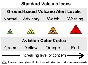
| GREEN: | Volcano is in typical background, noneruptive state or, after a change from a higher level, volcanic activity has ceased and volcano has returned to noneruptive background state. |
| YELLOW: | Volcano is exhibiting signs of elevated unrest above known background level or, after a change from a higher level, volcanic activity has decreased significantly but continues to be closely monitored for possible renewed increase. |
| ORANGE: | Volcano is exhibiting heightened or escalating unrest with increased potential of eruption, timeframe uncertain, OR eruption is underway with no or minor volcanic-ash emissions [ash-plume height specified, if possible]. |
| RED: | Eruption is imminent with significant emission of volcanic ash into the atmosphere likely OR eruption is underway or suspected with significant emission of volcanic ash into the atmosphere [ash-plume height specified, if possible]. |
| UNASSIGNED: | Ground-based instrumentation is insufficient to establish that a volcano is in a typical background level (GREEN / NORMAL). When activity at such a volcano increases to the point of being detected by remote sensing, distant seismic networks, or eye witness reports, an alert level and color code are then assigned accordingly. When activity decreases, the volcano goes back to UNASSIGNED without going through GREEN / NORMAL. |
| NORMAL: | Volcano is in typical background, noneruptive state or, after a change from a higher level, volcanic activity has ceased and volcano has returned to noneruptive background state. |
| ADVISORY: | Volcano is exhibiting signs of elevated unrest above known background level or, after a change from a higher level, volcanic activity has decreased significantly but continues to be closely monitored for possible renewed increase. |
| WATCH: | Volcano is exhibiting heightened or escalating unrest with increased potential of eruption, timeframe uncertain, OR eruption is underway but poses limited hazards. |
| WARNING: | Hazardous eruption is imminent, underway, or suspected. |
| UNASSIGNED: | Ground-based instrumentation is insufficient to establish that a volcano is in a typical background level (GREEN / NORMAL). When activity at such a volcano increases to the point of being detected by remote sensing, distant seismic networks, or eye witness reports, an alert level and color code are then assigned accordingly. When activity decreases, the volcano goes back to UNASSIGNED without going through GREEN / NORMAL. |
 |  |

Volcanic Ash Clouds
The principal hazard associated with future explosive eruptions of Alaska volcanoes is the generation of volcanic ash clouds which are explosively blasted high into the atmosphere and then drift away from the volcano with the wind. Ash-rich clouds produced during large eruptions can reach heights of 30,000 to 65,000 ft (10 to 20 km) or more above the volcano, although most Alaska eruptions are smaller (a few thousand ft to 20,000 ft). Prevailing North Pacific winds usually carry ash clouds eastward from the volcano, but dispersal in other directions is possible, depending on wind patterns at the time of the eruption.
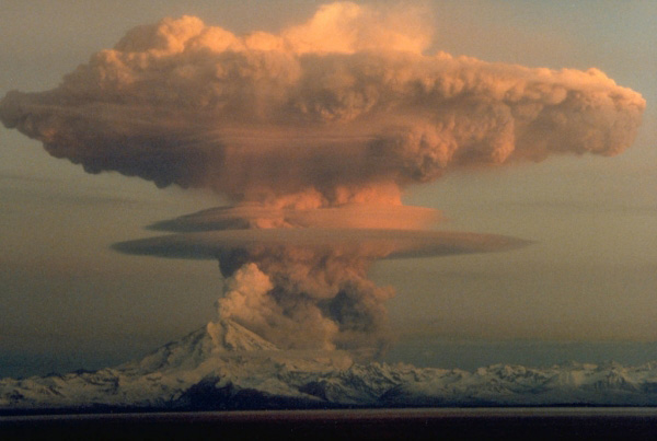
Ascending eruption cloud from Redoubt Volcano as viewed to the west from the Kenai Peninsula. The mushroom-shaped plume rose from avalanches of hot debris (pyroclastic flows) that cascaded down the north flank of the volcano. A smaller, white steam plume rises from the summit crater. Photograph by R. Clucas, April 21, 1990.

North Pacific and Russian Far East air routes (gray lines) pass over or near more than a hundred potentially active volcanoes (red triangles). Aircraft flying along these routes, some of the busiest in the world, carry more than 50,000 passengers and millions of dollars of cargo each day to and from Asia, North America, and Europe. In the North Pacific region, several explosive eruptions occur every year. Ash from these eruptions, which has caused jet engines to fail, is usually blown to the east and northeast, directly across the air routes.
Alaska airspace is extremely busy with long-range, wide-body aircraft as well as bush planes and smaller aircraft. The Ted Stevens Anchorage International Airport is the fifth busiest cargo airport in the world (Airports Council International, 2014), and the busiest cargo airport in the United States. More than 50,000 people fly over or very near Alaska volcanoes as they travel the North Pacific (NOPAC) and Russian Far East (RFE) air routes. The high volume of air traffic is due to Alaska’s unique geographic location. All direct air routes between the United States (even Los Angeles and New York) and Asian cities such as Tokyo and Hong Kong pass along the NOPAC routes. Most of the aircraft carrying freight between Europe and Asia come through Alaska for refueling. A considerable percent of all air freight on earth passes near Alaska’s many volcanoes.
Everyone in an ashfall zone will be exposed to the effects of volcanic ash. Fine grained volcanic ash can infiltrate all but the most tightly sealed buildings and machinery and is often small enough (less than 10 microns) to be inhaled deeply into the lungs. Ashfall over extensive areas can prevent travel for days because of poor visibility, slippery roads, and damage to vehicles. Power outages may occur before, during, and after an ashfall either due to equipment failure or because power facilities are temporarily shut down to prevent damage. Afterwards, wind and human activity can stir up ash for weeks to years.
In most situations, acting on a few general principles will reduce the effects of ash and make cleanup operations easier. These principles apply to households, businesses, and communities.General principles:
Keep ash out of buildings, machinery, vehicles, downspouts, water supplies, and wastewater systems (for example, storm drains) as much as possible. The most effective method to prevent ash-induced damage to machinery is to shut down, close off or seal equipment until ash is removed from the immediate environment, but this may not be practical in all cases, especially for critical facilities. Minimize exposure to airborne ash by using dust or filter masks (or a wet cloth, for example a handkerchief) and minimizing travel.
Coordinate cleanup activities with neighbors and community-wide operations (learn the cleanup guidelines and instructions of your local community and leaders). After an ashfall, promptly notify building owners to remove ash from roofs in a timely manner to prevent streets from being repetitively cleaned. Stay informed of volcanic activity in your area, especially during a period of unrest, and know what to expect, including the type of eruptions that can occur and how much warning is possible for ashfall in your area once an explosive eruption occurs. Learn about evacuation procedures, if any, in your area. Prepare for an emergency by having critical provisions and supplies needed to support your family, business, or community for at least several days; for example, food, water, medicine, and shelter, dust masks and other personal protection equipment, spare filters and parts for machinery and vehicles. Develop and test a contingency plan that can be used in a variety of emergencies, but not necessarily focused on volcanoes.